This item has been sold, but you can enter your email address to be notified if another example becomes available.


|
||

|

|
|

|
Stock# 34511
Description
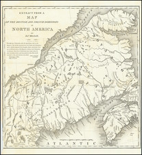
Elegant map of Maine by Moses Greenleaf, one of the most important New England map publishers of the 19th Century.
The map is highly detailed, showing towns, roads, rivers, lakes, mountains, and a host of other details.
The map locates the disputed Canadian-American border along Maine's northern boundary, which was then very hotly contested, including the American Claims north of Temiscouata Lake, the English/New Brunswick claims south of Chimney Lake and the boundary line recommended by the King of the Netherlands during the boundary dispute negotiations between the US and England.
A fascinating map and one of the few atlas maps to address the boundary dispute in such detail.

![Partie De L'Amerique Septent? Qui comprend La Nouvelle France ou Le Canada . . . [Large Great Lakes Inset]](https://storage.googleapis.com/raremaps/img/small/48752.jpg)