|
||

|

|
|

|
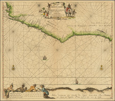
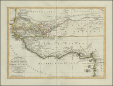
Rare separately issued map of a part of West Africa, showing Sierra Leone and the Southwestern Part of Guinea, published in London by James Wyld.
Wyld's map presents one of the most detailed treatments of the country of Sierra Leon to appear on a printed map in the 19th Century. The map shows in fine detail, the rivers, towns, and roads in the region.
Of note, the map shows the routes of the explorations in the region by Wall & Winterbottom (1794), Surgeon O'Beirne (1821), Major Laing (1822) and Jack Le Bore (1822). It also includes a table identified as the "Returns of the Trade Population &c. of Sierra Leone 1817 to 1825 abstracted from Returns laid before Parliament (Paper No. 520) July 1825, &c.", providing an excellent annual report of British Trade with Sierra Leone, including categories defined as "Liberated Africans" and "Nova Scotians disbanded Black Soldiery &c."
A highly informative map.
James Wyld Sr. (1790-1836) was a British cartographer and one of Europe’s leading mapmakers. He made many contributions to cartography, including the introduction of lithography into map printing in 1812.
William Faden, another celebrated cartographer, passed down his mapmaking business to Wyld in 1823. The quality and quantity of Faden’s maps, combined with Wyld’s considerable skill, brought Wyld great prestige.
Wyld was named geographer to Kings George IV and William IV, as well as HRH the Duke of York. In 1825, he was elected an Associate of the Institution of Civil Engineers. He was one of the founding members of the Royal Geographical Society in 1830. Also in 1830, his son, James Wyld Jr., took over his publishing house. Wyld Sr. died of overwork on October 14, 1836.
James Wyld Jr. (1812-87) was a renowned cartographer in his own right and he successfully carried on his father’s business. He gained the title of Geographer to the Queen and H.R.H. Prince Albert. Punch (1850) described him in humorous cartographic terms, “If Mr. Wyld’s brain should be ever discovered (we will be bound he has a Map of it inside his hat), we should like to have a peep at it, for we have a suspicion that the two hemispheres must be printed, varnished, and glazed, exactly like a pair of globes.”