


|
||

|

|
|

|
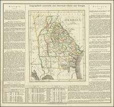
Rare German edition of Carey & Lea's map of Georgia. Many of the early counties are still oversized, especially in the south and the west. The border with Alabama is dominated by the Cherokee and Lower Creek Indian Lands. Includes a towns, early roads, a number of forts and other interesting early details. Florida below is still divided into East and West Florida. Carey & Lea published the Atlas of North America in 1822. The atlas was a commercial success and was re-issued in 1823 and 1827. It adopted the style of the Lavoisne Atlas, which had been published in London and later in Philadephia by Carey & Lea, with descriptive text on two or three sides of the maps, rather than on the verso or other pages. A French edition of the Atlas was published by Buchon in Paris in 1825. This German edition by Weiland is by far the rarest. All of the maps have been re-engraved by the Weimar Geographischen Insitut, a well regarded cartographic publisher. The engraving quality of the maps far surpasses the American edition. Weiland actually added several maps which did not appear in the Carey & Lea or Buchon additions. One of the earliest and rarest maps of Georgia printed outside the US.
![[The First Maps Printed Color] Cartes en Couleur des Lieux Sujets aux tremblements de Terre Dans toutes les parties du Monde Selon le Sisteme de l’impulsion Solaire](https://storage.googleapis.com/raremaps/img/small/52293op.jpg)

![[ Florida Indians - Destroying the Enemy's Towns By Night ] Hostium oppida noctu incendendi ratio. XXXI.er absagen](https://storage.googleapis.com/raremaps/img/small/97385.jpg)
