![[ Southern Railroads ] Railroad Map of the Southern States Shewing the Southern & Southwestern Railway Connections With Philadelphia. 1862 . . . Prepared by Thomas Kimber Jr., Chairman of the Committee on Inland Transportation of the Board of Trade of Philadelphia By P.S. Duval](https://storage.googleapis.com/raremaps/img/small/103211.jpg)


|
||

|

|
|

|
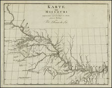
Nice example of this extremely rare separately issued map of the Southern part of the United States, extending west to Texas, Indian Territory and Kansas, prepared at the beginning of the Civil War by the Philadelphia Board of Trade.
The map focuses primarly on the railroads (existing and proposed) crossing the United States into the Transmississippi West at the outset of the Civil War.
The timing of the preparation of this map is especially curious, as it seems relatively unlikely that the prospects of trade betweeen Philadelphia and the areas shown would have been strong in 1862. A later and equally rare edition of the map appears with the variant title beginning with Hazard's Rail Road Map
The map is apparently very rare on the market, as we were unable to locate another example at auction or in a dealer catalog in the past 30 years.
The following advertisement in The Continental Monthly extolled the virtues of the map:
The information for this map was recently obtained by A PERSONAL TOUR THROUGH THE SOUTH, as well as by the information given by THE PRESIDENT OF EVERY RAILROAD; the corrections make it COMPLETE TO THE PRESENT HOUR; and it gives so recent and such valuable facts concerning all the rail roads, that the War Department immediately authorized its publication, and distributed ONE THOUSAND COPIES among the Generals and Colonels of the Army; the order having been supplied, no further delay in issuing the map will occur, and subscribers can now be supplied at the following prices:
Sheets, Carefully Colored, ....... $1.00
Sheets, Carefully Colored, in a Neat Cloth Case, ..... 1.50
Same, Carefully Colored, Mounted on Muslin, Folded, ... 2.50
Do. Carefully Colored, on Rollers, Varnished, - - - 2.50
Do. Carefully Colored, Beautifully Mounted and Framed for Office Use, 3.00
Several weighty reasons for purchasing "HAZARD'S RAILROAD AND MILITARY MAP OF THE SOUTHERN STATES." It is the official map; and therefore must be the best and the most reliable, which is everything, particularly at this time when a good map is of such universal interest. This is the ONLY MAP that has been officially adopted for Government purposes.
Id. The Coast is so distinct and accurate, it shows every little island and inlet, and is correct as the large maps issued by the Coast Survey Office.
Id. It is very cheap. It is thirty-two by fifty-five inches, and is one of the best specimens of map engraving ever done in this country. .
Id. It presents the whole Southern States at one view, and the railroads are so distinctly marked as to show at a glance the most important strategical points. General Mcclellan has acknowledged in several communications the "great importance to his movements of the accurate information in regard to the Southern Railroads, conveyed in this map."
Testimonials of the same character have been received from Prof. A. D. Bache, of the Coast Survey Department, as to the great accuracy of the coast line; and one hundred 'exra-copies ordered "to distribute among the Commanders of the Atlantic and Gulf Squadrons," which have been furnished.
While Adopted For Its Accuracy by the Military Authorities, as has been stated, it is yet more especially a Commercial Map, and was at first intended expressly for that pupose. Hence, its value will be undiminished when the war is over, and renewed attention is directed to that section.
After what has been said of The Great Value Of This Map To Every Intelligent Person, is there any one who will be without it? Particularly since its price has been made below as that of inferior maps, in order to keep up with the times. We are constantly told by those who already have several of the maps rushed upon the public, that they have laid them aside and use only this one.
Accuracy And Distinctness are the characteristics of this map, the only one authorized by the Government.
Just published and for sale by
THOMAS. T. EVANS, General Agent for New-York State,
532 BROADWAY, NEW-YORK.

![[ Northern Pacific Railroad ] NEW 7-30 GOLD LOAN OF THE Northern Pacific Railroad Co. SECURED BY FIRST MORTGAGE ON RAILROAD AND LAND GRANT. SAFE! PROFITABLE! PERMANENT!](https://storage.googleapis.com/raremaps/img/small/101828.jpg)
![[First Map of the Mississippi River] Carte de la decouverte faite l'an dans l'Amerique Septentrionale](https://storage.googleapis.com/raremaps/img/small/93571.jpg)