|
||

|

|
|

|
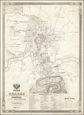
Fine example of this important early map of Western Galicia, as given to Austria by the third Partition of Poland (1795).
Benedicti's map is the first systematic scientific survey of the region, undertaken by the Austrian government at a time when the systematic survey of large regions wa becoming a military and political imperative in Europe.
Benedicti's map is based upon an Austrian Survey of the region between 1801 and 1804, conducted under the leadership of Anton Mayer von Heldensfeld (1764-1842), military officer under Archduke Charles of Austria (1771- 1847). While the map bears the date of 1808, the map was in fact prepared between May 1808 and the Summer of 1811, such that by the time the last sheets were completed, Benedicti had died and Western Galicia was no longer a part of Austria.
West Galicia was an administrative region of the Austrian Habsburg Monarchy, constituted from the territory annexed in the course of the Third Partition of Poland in 1795. After the failed Uprising of 1794, Emperor Francis II of Habsburg agreed with Empress Catherine II of Russia to again divide and thereby completely abolish the remaining Polish-Lithuanian Commonwealth, a decision which Prussia joined on October 24, 1795. Austria, which had not participated in the Second Partition, received a share that comprised the lands north of the Kingdom of Galicia and Lodomeria gained in the First Partition of 1772. Habsburg then occupied whole Lesser Poland, stretching along the upper Vistula river to the outskirts of Praga and Warsaw, the tributaries of Bug and Pilica forming the northern border with New East Prussia.
A fine example of this important map.
![[ Siege of Krakow ] Was gestalt des Koniges in polen Sigismundi Braut Anna Caroli, Ertzhertzogen Von Osterreich Christmilter gedechnus Tochter, den 28 Mayus. 92 bij Crocaw . . .](https://storage.googleapis.com/raremaps/img/small/98964.jpg)
![[ Holy Roman Empire, Poland, Baltic, etc. ] Germania VI Nova Tabula (First state!)](https://storage.googleapis.com/raremaps/img/small/94645.jpg)