


|
||

|

|
|

|
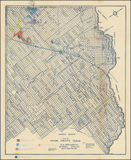
New Columbia / Belgrade / Town of Salem Section of the Official Survey Map Which Established The Boundary Between The Republic of Texas and The United States.
One section from this extremely rare 10 sheet set of the maps prepared by the United States Government in conjunction with the establishment of the International Boundary between the United States and the Republic of Texas, as set down by the Joint Commission for Marking the Boundary.
This fine set of mammoth maps was the official depiction of the international boundary between the Republic of Texas and the United States from the Gulf of Mexico to the Red River. The maps are of paramount importance, representing the first surveyed delineation of the Republic of Texas. In essence, the maps serve as a part of the birth certificate of the new Republic.
There are only three complete sets recorded in institutions, none of which are in Texas.
BACKGROUND AND IMPORTANCE
Following the recognition of the Republic of Texas by the United States, on April 25, 1838 the two nations signed a convention for running the boundary between the two nations. Article I provided that
Each of the contracting parties shall appoint a commissioner and surveyor, who shall meet, before the termination of twelve months from the exchange of the ratifications of this convention, at New Orleans, and proceed to run and mark that portion of the said boundary which extends from the mouth of the Sabine, where that river enters the Gulph of Mexico, to the Red River. They shall make out plans and keep journals of their proceedings, and the result agreed upon by them shall be considered as part of this convention…
Offered here is a specially prepared large format set of 4 maps on 10 sheets, representing the first publication of the Joint US - Republic of Texas Boundary Commissioners' work.
In the Introduction to his Bibliography of Texas, Streeter states that this set of maps is one of six cartographic items "especially desirable for a Texas collection" and "of prime importance," along with with the 1799 Carta Esferica, the 1809 Humboldt Carte du Mexique, the 1830 Austin map of Texas, the 1833 Burr map of Texas, and the 1845 Wilson map of Texas (Streeter III:1, p. xv). Later in the Bibliography he writes:
The maps are most important in Texas history, in that they show the final boundary between Texas and the United States from the Gulf of Mexico to the Red River, resulting from the settlement of the boundary dispute between the two countries…. There was no question of interpretation of the boundary line from the 32d parallel to the Red River, but its actual location was so little known that its survey as recorded in these boundary maps showed that quite a large area thought to be part of Arkansas was in fact part of Texas. (Streeter III:2, p. 1842)
Though some of the sheets bear a date of 1840, Streeter cites documentary evidence indicating that they were completed in late 1841 or the earliest days of 1842. (III:2, p. 1842) Further, according to Streeter the publication of this set preceded that of the smaller-scale versions of the maps in the Message from the President…Proceedings of the Commissioner Appointed to Run the Boundary Line between the U.S. and the Republic of Texas. (Washington: Senate Ex. Doc. 199, 27th Cong. 2nd Sess., 1842.)
DESCRIPTION
The set consists of 4 maps on a total of 10 sheets. The scale is very large, ranging from one mile to the inch to as large as one-fifth mile to the inch. Each showing the key findings of the boundary survey as well as a great deal of topographical and in some cases hydrographic detail. The maps are as following:
1. Surveyed under the direction of Major J.D. Graham, U.S. Topl. Engineers by Lieut. T.J. Lee, U.S. Topl. Engineers and Capt. P.J. Pillans / Drawn by Lieut. T.J. Lee, U.S. Topl. Engineers, Texas Army, SABINE PASS AND MOUTH OF THE RIVER SABINE IN THE SEA.
Lithograph, ca. 26.5" high by 18.5" wide, uncolored. Phillips, Maps, pp. 753, 842. Streeter, Texas, III:1438
2 . Lieut. T.J. Lee, U.S. Topographical Engineers / Lith. in colours by P. Haas, MAP OF THE RIVER SABINE FROM ITS MOUTH ON THE GULF OF MEXICO IN THE SEA to Logan's Ferry IN LATITUDE 31? 58' 24". NORTH. Shewing the Boundary between the United States and the Republic of Texas between said points as marked and laid down by Survey in 1840 under the direction of the Commissioners appointed for the purpose under the 1st Article of Convention signed at Washington April 25th, 1838.
Lithograph on 5 unjoined sheets, each approx. 30" wide and between 29"-36" in height (if joined yielding a map more than 12 feet high). Some wash color. Phillips, Maps, pp. 753, 842. Streeter, Texas, III:1439.
3. Drawn by A.B. Gray, MAP of the RIVER SABINE from LOGAN'S FERRY to 32ND. DEGREE OF NORTH LATITUDE. Shewing the boundary between the United States of America and the Republic of Texas between said points, as marked and laid down by Survey in 1841, under the direction of the Joint Commission appointed for that purpose under the 1st. Article of the Convention signed at Washington on the 25th. day of April 1838.
Lithograph, ca. 19" high by 27"w, outline color along Texas-US boundary. Phillips, Maps, pp. 753, 842. Streeter, Texas, III:1440.
4. J. Edmd. Blake, 1st Lieut. U.S. Topog. Engs., A2. Part of the Boundary between the UNITED STATES and TEXAS, from Sabine River Northward, to the 36th mile mound. [with:] B2. Part of the Boundary between the UNITED STATES and TEXAS, North of Sabine River from the 39th [i.e., 36th] to the 72nd mile mound. [with:] C2. Part of the Boundary between the United STATES and TEXAS, North of Sabine River from the 72nd mile mound to Red River.
Lithograph on 3 unjoined sheets, each ca. 28.5" high by 22" wide, uncolored. Phillips, Maps, pp. 753, 842. Streeter, Texas, III:1441-1443.
RARITY
Of the 6 items listed by Streeter, the US - Republic of Texas Joint Commission map set is among the rarest, rivaled only by the Wilson. Streeter knew of only 2 complete sets, being his own (now at Yale) and 1 at the Library of Congress, with partials sets at the Boston Public Library, the New York Public Library, and the American Geographical Society Library. OCLC lists third complete set at the Massachusetts Historical Society, with partial sets at a number of other institutions. Other than the Streeter set (now at Yale), we know of no other complete sets in private hands in the past century. Likewise, we have been unable to locate a complete set at any Texas institution as of 2013.

![[DeWitt Clinton Copy] An Account of Expeditions to the Sources of the Mississippi, and through the Western Parts of Louisiana, to the Sources of the Arkansaw, Kans, La Platte, and Pierre Jaun, Rivers During the years 1805, 1806 and 1807. And a Tour through the Interior Parts of New Spain. in the year 1807.](https://storage.googleapis.com/raremaps/img/small/81745.jpg)
![Texas [The Rand McNally Vest Pocket Map of Texas]](https://storage.googleapis.com/raremaps/img/small/86827.jpg)