


|
||

|

|
|

|
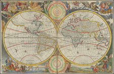
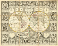
First edition of Clouet's beautifully engraved large scale double hemisphere map of the World.
The Clouet/Mondhare double hemisphere map of the World is one of the most decorative double hemisphere wall maps of the world published in the second half of the 18th Century. The map continues the French Aristocratic tradition popularized during the reign of Louis XIV. In this grand tradition, the Clouet/Mondhare map serves the dual purpose of being both a spectacular object, utilized by the French Aristocracy of the 18th Century in decorating libraries and salons, and a statement of the worldliness of the owners, depicting the progress of the exploration of the world and scientific models of the known universe, in a perfect marriage with imagery from the classical world and scenes from the lives of key figures of the Old Testament.
The map provides a fine depiction of the most up-to-date information derived from modern explorers, although this edition pre-dates the discovery of Hawaii and the southeastern coastline of Australia, which would be added in the next edition of the map. The earlier routes of numerous 17th and 18th Century explorers are noted, with particular emphasis given to the explorations of Abel Tasman in the Southern Hemisphere, both in New Zealand and Australia.
While the routes of many major explorer's are depicted, Mondhare has retained the mythical depiction of the Sea of the West in North America and offers a number of tantalizing options for a northwest passage, while also including a massive nascent depiction of Alaska and the Aeulutian Archipelago, which was then at the end of a 40 year period of debate between the theories of the De L'Isle family of mapmakers, Thomas Jefferys and the Russian Academy.
The map is embellished with eight small circular astronomical diagrams including images of lunar and solar eclipses and the known solar system. Supporting each hemisphere is an image of Atlas. On the outer edge of the printed images are twenty vignettes from the Old Testament showing Biblical scenes with descriptive text in French and Spanish. Below the cusp is a an armillary sphere.
A striking example in very nice condition.
Jean-Baptiste Louis Clouet (1730-ca. 1790) was a mapmaker with premises in both Paris and Cadiz. He was eventually named Royal Geographer of the Academie des Sciences de Rouen. Although he made several lavish wall maps, he is best known for Geographie Moderne (1776-93).
![[Mussolini Celebrates Pearl Harbor] Grande Carta Del Pacifico](https://storage.googleapis.com/raremaps/img/small/65273.jpg)