|
||

|

|
|

|
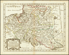
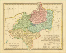
Nice example of the rare Valk & Schenk edition of this important map of Lithuania at its grandest scale (incuding Poland, Ukraine and part of Russia), including a large inset of the Dniepr River, based upon Hessel Gerritsz's four sheet map of the same title.
Hessel Gerritsz prepared his original map from manuscript drafts prepared under the instructions of Prince Nicolas Christophe Radziwill. His four sheet map was first issued in 1613 by Willem Blaeu, under Blaeu's original imprint Guilhelmus Janssonis. This is one of the earliest maps published by Blaeu, who did not incorporate this map into an atlas until approximately 1630.
The Radziwill map is one of the most important works of European cartography from the end of the 16th and the beginning of the 17th century and is an important contribution to the progress in the mapping of the whole continent. The map had its beginning in 1586 when Prince Michael Radziwill commissioned M.Strubicz to survey the entire Lithuanian state which then included Poland. Strubicz's map was so accurate and detailed that it provided the basis for all subsequent maps of the area during the 17th and 18th centuries. In addition to the usual topographical details, there is considerable historical information also provided.
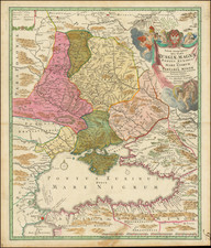
The map includes the Lithuanian coat of arms, title cartouche, sailing ship and vignettes within the image. Buczek remarks that
the map ... occupies a very prominent position among ... European cartography ... and ... was also a great step forward in the mapping of the lands then forming part of Poland ... there are on the map 1020 towns and villages and within the boundaries of the Grand Dutchy of Lithuania alone there are 511 towns, 31 villages, and 1 monastery.
Following Blaeu's original 4-sheet version of the Gerritsz map, Blaeu and Jansson issued single sheet versions, the latter of which was re-issued by Valk & Schenk at the end of the 17th Century. The Valk & Schenk editon is the rarest on the market.
Jan Janssonius (also known as Johann or Jan Jansson or Janszoon) (1588-1664) was a renowned geographer and publisher of the seventeenth century, when the Dutch dominated map publishing in Europe. Born in Arnhem, Jan was first exposed to the trade via his father, who was also a bookseller and publisher. In 1612, Jan married the daughter of Jodocus Hondius, who was also a prominent mapmaker and seller. Jonssonius’ first maps date from 1616.
In the 1630s, Janssonius worked with his brother-in-law, Henricus Hondius. Their most successful venture was to reissue the Mercator-Hondius atlas. Jodocus Hondius had acquired the plates to the Mercator atlas, first published in 1595, and added 36 additional maps. After Hondius died in 1612, Henricus took over publication; Janssonius joined the venture in 1633. Eventually, the atlas was renamed the Atlas Novus and then the Atlas Major, by which time it had expanded to eleven volumes. Janssonius is also well known for his volume of English county maps, published in 1646.
Janssonius died in Amsterdam in 1664. His son-in-law, Johannes van Waesbergen, took over his business. Eventually, many of Janssonius’ plates were sold to Gerard Valck and Pieter Schenk, who added their names and continued to reissue the maps.