|
||

|

|
|

|
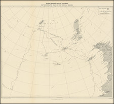
Remarkable large format map of the South Pole, by Vincenz von Haardt, published by E. Hoelzel in Vienna, 1895.
Vincenz von Haardt's map of the South Polar regions is generally regarded as the first modern wall map of the South Pole and provides a highly detailed treatment of the tracks of explorers during the great period of Antarctic exploration.
This fascinating chromolithographic was devised by Vincenz von Haardt (1843-1914), and issued immediately in the wake of the Eleventh German Geographical Congress, held in Bremen on 17-19 April 1895. The "South Polar question" was billed as the foremost seminar topic of this important meeting.
By the end of the nineteenth-century, the Antarctic remained the last frontier of exploration. While many voyages had charted its icy and foreboding shorelines, its interior was still a complete enigma. Leading explorers and scientists gathered at Bremen in an effort to forge a path forward. Not only did many pressing issues of academic curiosity remain unanswered, the national pride of the various competing European powers was at state. This timely map gives the most accurate and detailed account of all recorded previous expeditions, and defines the state of play as it existed in 1895.
It was not until the later eighteenth-century that explorers ventured far enough south to gain some evidence that a Southern Polar continent did indeed exist. In 1773, Captain James Cook reachedthe massive seas of pack ice that girdle the continent, although he did not sight its shores. That distinction belongs to the Russian expedition commanded by Fabian Gottlieb von Bellingshausen and Mikhail Lazarev, when they approached the coast in 1820. The following year, an American sealer, John Davis, made the first recorded landing on Antarctica. With the tracks of the expeditions encircling the continent emblazoned on the map in vibrant colors, several important voyages followed; including those of D'Urville (1840), Wilkes (1840), Ross (1841& 42), Moore (1845), and more recently that of Nares (1874).
Very much in the news at the time of the creation of this map was the Norwegian expedition led by Captain Carl Anton Larsen, which aboard the barque Jason explored the continent's coastal waters in 1892. Importantly, Larsen discovered fossils along the shore, for which he was granted an award by the Royal Geographical Society in London. The Geographical Journal of the Royal Geographical Society, Volume 6 (July to December 1895), notes:
This is a carefully comiled map of the Antarctic regions, on which all the tracks of explorers are laid down, in addition to which, by means of isotherms and isobars, separate maps, and notes, a large amount of information is given with regard to magnetism, winds, temperature, atmospheric pressure, etc.
Evident on the map, the coastal regions had by this time been relatively well explored, with the next great leap remaining a dangerous and uncertain voyage into the heart of the icy continent. In this sense, the map represents the epistemological point of departure for this next chapter. In 1893, Captain Larsen and his men had main the first tentative steps in this direction by becoming the first persons to ski atop what would be known as the Larsen Ice Shelf.
True to the sprit of empiricism and intellectual curiousity which still prevailed in the Germanic countries, in the wake of the Humboldt brothers, the map features an immense amount of scientific data. The maritime spaces of the main map are traversed by the lines of ocean currents, while the smaller inset maps located in the corners of the composition, detail such variables as water and air temperature and magnetic inclination and declination.
Haardt's map is without question the finest and most detailed cartographic record of Antarctic Exploration taken just before the legendary expeditions of Shackleton, Amundsen and Scott.
No examples listed in OCLC.
Vinzenz Haardt von Hartenthurn was a cartographer and military geographer.
Haardt was born in Iglau (Jihlava, Moravia) on August 13, 1843, and died in Vienna on August 1, 1914. His father was a general major.
Vinzenz finished his studies at the Theresian Military Academy and the Imperial Royal War School in Vienna. He participated in the 1866 campaign in Italy, fought against the insurrection in Cattaro in 1869, and became a captain in the General Staff. By 1872, he was a professor at the Technical Military Academy and from 1877 to 1896, he was the scientific head at Eduard Hölzel. In 1897, he became the head of the 1st department at the Military Geographical Institute, was made a government councilor in 1896, and a ministerial councilor in 1912. He attended numerous international geographical congresses and the international earth map conference in London in 1909 and in Paris in 1913.
His work focused on cartography and school geography, contributing to atlas and wall maps, and writing explanations for map works. Notably, he worked on the wall map of the Alps and the text for the portable edition of the "Geograph. Charakterbilder" along with Fr. Umlauft. His research on the history of cartography, especially on the cartography of the Balkan Peninsula in the 19th and 20th centuries, the development of cartography in Austria, and the Military Geographical Institute, are of lasting value. He was also the editor of the "Mitteilungen der Geographischen Gesellschaft Wien" in 1884 and 1885.
His works include several editions of the Kozenn Atlas, the Geographic Atlas of the Austro-Hungarian Monarchy in 1883, a wall map of the Alps in 1882, an overview map of the ethnographic conditions of Asia in 1887, a South Pole map in 1895, and a hand map of Bosnia and Herzegovina in 1907, among others. He also authored significant writings on the division of the Alps, the development of cartography in Austria, and the military geographical Institute, as well as other contributions to the understanding of military topographical work in Europe and the cartography of the Balkan Peninsula.

![[ Aurora Borealis ] Karte der Geographischen Verbreitung des Nordlichtes. Von H. Fritz](https://storage.googleapis.com/raremaps/img/small/98483.jpg)
![[Rare Second State] Poli Arctici, et Circumiacentium Terrarum Descriptio Novissima](https://storage.googleapis.com/raremaps/img/small/93127.jpg)