


|
||

|

|
|

|
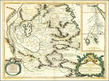
Rare Proof State of the Pierre Mortier / Romeyn De Hooghe map of the Mediterranean, embellished with 38 inset maps and views of the major ports and harbors of the Mediterranean.
Fine example of Romeyn De Hooghe's monumental chart of the Mediterranean Sea which includes numerous galleons and galleys, with allegorical figures and sea monsters embellishing the insets. The chart appeared in a special section of Mortier's Neptune François, separately titled Cartes Marines a l'Usage des Armées du Roy de la Grande Bretagne. The nine charts in this section, all engraved by Romeyn de Hooghe, are described by Koeman as the "most spectacular type of maritime cartography ever produced in 17th century Amsterdam." The chart of the Mediterranean is the largest and most intricately decorated of the nine.
Mortier's motives in the production of this atlas, was to flatter the Dutch king on the British throne since the Glorious Revolution of 1688, William III, to whom it is dedicated. The unprecedented size of the atlas and the use of artists such as de Hooghe, made this work one of the most lavish of the period. Again Koeman calls it the "most expensive sea atlas" of the period, "intended more as a show-piece than something to be used by the pilots at sea".
De Hooghe was one of the most famous artist/engravers of the period. His work is highly coveted by map and print collectors.
The map is known in 4 states, according to Egmond's work on Covens & Mortier:
- State 1: Title Misspelled (this example--1 "R" in Mediteranee)
- State 2: Title Corrected to Mediterranee
- State 3: Date Removed
- State 4: Covens & Mortier Imprint
This apparent proof state can be distinguished from the later states of the map by the misspelling of Mediterranee in the title of the map (only 1 "R", rather than the curious overlaid "RR" on the later editions), and by the lack of titles and numbers on the 3 scales of miles along the bottom (completed in our example by the inclusion of the titles in an early manuscript hand). The words in the dedication, title cartouche, and many of the larger printed words in the map, also include parallel guide lines which are typical of proof states and which are typically erased from the copper plate after the map is ready for publication. See for example the words "Espagne," "Portugal" and "Podolie" in the body of the map and the phrase "Tous los courans porent contre la terre de Barbarie" below the Balearic Islands, all of which are removed in the final version of Mortier's 1694 map.
We are unaware of another example of this map appearing on the market.
![De Gelegentheyt van't Paradys en't Landt Canaan mitsgaders d'eerst bewoonde Landen der Patriachen uyt de H. Schristure …[Shows Cyprus]](https://storage.googleapis.com/raremaps/img/small/82746.jpg)
![[Istanbul] Die Statt Constantinopel in Turckey](https://storage.googleapis.com/raremaps/img/small/63022.jpg)
![Istria e Alpi Giulie [Istria and Julian Alps]](https://storage.googleapis.com/raremaps/img/small/88209.jpg)
![[English Language Edition!] Natoliae Quae Olim Asia Minor Nova Descriptio [with] Aegypti Recentior Descriptio [with] Carthageinis Celeberrimi Sinus Typus [shows Cyprus]](https://storage.googleapis.com/raremaps/img/small/78508.jpg)
![[ Basque Harbors ] Kaarte over Pasages Havn / Kaart over Byen St. Sebastian og dens Havn / Kaart over Sudlobet til Bilbao / Havenen ved Santoña](https://storage.googleapis.com/raremaps/img/small/39054se.jpg)