


|
||

|

|
|

|
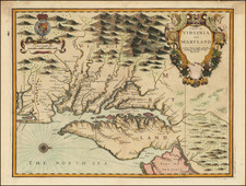
John Speed's Edition of John Smith's Seminal Map of Virginia.
Nice example of John Speed's map of Virginia and Maryland, which was engraved by Francis Lamb and first appeared in the enlarged edition of Speed's Atlas in 1676.
Speed's map of Virginia and Maryland is one of the first to incorporate the information from Augustine Herrman' Virginia and Maryland As it is Planted and Inhabited this present Year 1670 Surveyed and Exactly Drawne by the Only Labour & Endeavour of Augustin Herrman Boehemiensis, a few years prior to the Speed map's publication. Fascinating description of the Maryland and Virginia in English text on the verso.
The majority of the cartographic information derives from John Smith's earlier map of Virginia. Speed's 4 maps of the English colonies in America hold the distinction of being the first "new" set of printed maps of the Colonies to appear in a commercial atlas after the English took control of what would become the British Colonies in North America, and later the first 13 states (although in truth these are Francis Lamb's maps, prepared for Thomas Bassett and Richard Chiswell, as Speed had been dead for half a century by the time these maps were engraved).
John Speed (1551 or '52 - 28 July 1629) was the best known English mapmaker of the Stuart period. Speed came to mapmaking late in life, producing his first maps in the 1590s and entering the trade in earnest when he was almost 60 years old.
John Speed's fame, which continues to this day, lies with two atlases, The Theatre of the Empire of Great Britaine (first published 1612), and the Prospect of the Most Famous Parts of the World (1627). While The Theatre ... started as solely a county atlas, it grew into an impressive world atlas with the inclusion of the Prospect in 1627. The plates for the atlas passed through many hands in the 17th century, and the book finally reached its apotheosis in 1676 when it was published by Thomas Bassett and Richard Chiswell, with a number of important maps added for the first time.
![[Richmond, Virginia Imprint] Map of the State of Virginia Containing The Counties, Principal Towns, Railroads, Rivers, Canals & All Other Internal Improvements. Published by West & Johnston. Richmond Va. 1862 . . .](https://storage.googleapis.com/raremaps/img/small/35235.jpg)