|
||

|

|
|

|
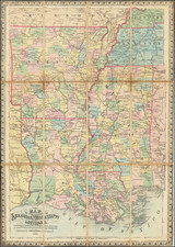
Rare and highly important Civil War Battle Map, published by Merrill in Chattanooga on May 2, 1864, for use by commanding officers in the field.
The map is one of only 200 copies originally printed in the days before the commencement of the Atlanta Campaign, and was produced in the field by a team of Army topographers and draughtsman. Merrill's map is one of the rarest and most important maps of the War, referred to by Stephenson as "the principal reference map for all field commanders in the initial stage of the Union campaign to capture Atlanta." The importance of the map cannot be overstated.
As noted by the Library of Congress in its exhibition of Civil War field maps:
The Topographical Department of the Army of the Cumberland, under the direction of Col. William E. Merrill, was chiefly responsible for providing the maps for the Atlanta Campaign. Thomas B. Van Horne in his History of the Army of the Cumberland (1875) notes that "The army was so far from Washington that it had to have a complete map establishment of its own. Accordingly, the office of the chief topographical engineer contained a printing press, two lithographic presses, one photographic establishment, arrangements for map-mounting, and a full corps of draughtsmen and assistants."
The lithographic presses were invaluable for quickly providing multiple copies of a map. However, the weight of the presses and stones made transporting them difficult, necessitating that they remain in a central depot near the front lines. . . the topographic engineers in the field had available to them a mobile "facsimile [sic] photoprinting device invented by Captain Margedant, chief assistant. . . The process, however, was expensive, and did not permit the printing of a large number of copies; therefore these maps were only issued to the chief commanders." . . .
In preparation for the coming campaign, the Topographical Department began the compilation of an accurate campaign map of northern Georgia. The best available map was enlarged to the scale of an inch to the mile. According to Van Horne, this was then "elaborated by cross-questioning refugees, spies, prisoners, peddlers, and any and all persons familiar with the country in front of us. It was remarkable how vastly our maps were improved by this process. The best illustration of the value of this method is the fact that Snake Creek Gap, through which our whole army turned the strong positions at Dalton and Buzzard Roost Gap, was not to be found on any printed map that we could get, and the knowledge of the existence of this gap was of immense importance to us."
Two days before the Atlanta Campaign began, the Topographical Department was informed of the date of advance. . . the single copy of the map of northern Georgia over which the Topographical Department had been laboring "was immediately cut up into sixteen sections and divided among the draughtsmen, who were ordered to work night and day until all the sections had been traced on thin paper in autographic ink. As soon as four adjacent sections were finished they were transferred to one large stone, and two hundred copies were printed. When all the map had thus been lithographed the map-mounters commenced their work. . . before the commanding generals left Chattanooga, each had received a bound copy of the map, and before we struck the enemy, every brigade, division, and corps commander in the three armies had a copy." Entitled "Map of Northern Georgia made under the direction of Capt. W. E. Merrill, Chief Topl. Engr.," the finished map measures 94 by 88 cm. It is lightly hand colored and indicates below the title and scale that it was "Lith. and printed at Topl. Engr. Office, Dept. Cumbd., Chattanooga, Tenn. May 2d, 1864." For ease of carrying in the field, the map was cut into 24 sections and mounted on cloth to fold to 16 by 23 cm. Pasted to the cloth mounting were cardboard covers to protect the map when folded (LC Civil War Maps no. S29-S30).
As noted by Michael Buehler:
The battle for Atlanta followed the Union victory at Chattanooga in November 1863. The first order of business was the preparation of an accurate field map, the result of which was this map of Northern Georgia, which was distributed to every commanding officer before the Army engaged in combat. Work on the map was carried out all through the winter of 1863-64 by engineers under the chief topographical engineer of the Union army of the Cumberland, William Merrill, "the most innovative and conscientious exponent of mapping during the Civil War."
Particular emphasis was put on the work of Sergeant N. Finegan and the Information Bureau, which expertly interviewed anyone who might be expected to have useful information on the region where the campaign was to be fought. So valuable was the intelligence he gleaned that the map was delayed while Finegan finished questioning his spies, scouts, refugees, travelers, prisoners, preachers, and peddlers -his 'motley crew,' in Merrill's words.
The map was completed and printed just five days before the campaign began on May 7 at the Battle of Rock Face Ridge. It depicts approximately the northwest one-third of the State of Georgia. Although imperfect due to the haphazard manner of its construction, it was undoubtedly the best map of northern Georgia then in existence, and a better map than any other Union command ever carried into a campaign.
As a testimony to the map's importance, it is reproduced . . . in virtually every study of Civil War mapping. General Sherman's two personal copies used during the campaign are in the Sherman Collection, Library of Congress. A special edition, printed in three parts on cloth, was issued for the use of cavalry officers "in the saddle."
A very nice example of this important Georgia map.
William Emery Merrill was the son of Captain Moses Merrill.
Merrill graduated first in his class from West Point in 1859, demonstrating early on his aptitude for military engineering. Following his graduation, he served as an assistant professor of engineering at West Point from September 1860 to July 1861.
His role as the head of the Topographical Department of the Army of the Cumberland during the Civil War, particularly in providing maps for the Atlanta Campaign, was a hallmark of his military career. Under his leadership, the department was equipped with advanced mapmaking technology, including lithographic and photoprinting equipment. His team's meticulous work in map production, notably the detailed map of northern Georgia for the Atlanta Campaign, was crucial for the Union Army. The maps produced under his direction were not only essential for tactical planning but also for operational maneuvering.
Colonel William E. Merrill, a key figure in the advancement of military cartography during the American Civil War, played a crucial role as the head of the Topographical Department of the Army of the Cumberland. His department's work, particularly in providing maps for the Atlanta Campaign, stands as a testament to the vital role of accurate cartographic information in military operations.
Under Merrill's direction, the Topographical Department was a self-sufficient unit, equipped with a printing press, two lithographic presses, a photographic establishment, facilities for map-mounting, and a team of skilled draughtsmen and assistants. This level of self-reliance was necessary due to the army's distance from Washington, requiring them to have their own comprehensive map production capabilities.
The lithographic presses, a central component of Merrill's operation, were instrumental in producing multiple copies of maps quickly. However, the logistical challenge of transporting these heavy presses required them to be stationed at a central depot near the front lines. To complement this, Merrill's team also utilized a mobile photoprinting device invented by Captain Margedant. This device, comprising a light box with India rubber baths and a supply of chemicals, allowed for the tracing of maps on thin paper laid over a sheet coated with nitrate of silver. Exposed to sunlight, this produced a white map on a black background. Despite its cost and limitation in producing large quantities, this method was vital for issuing updated maps to high-ranking commanders.
The Topographical Department's most significant achievement under Merrill was the creation of an accurate campaign map of northern Georgia. This task involved enlarging the best available map to a scale of an inch to the mile and refining it with information gathered from various sources, including refugees, spies, and prisoners. The meticulousness of this process was underscored by the fact that crucial geographic features, such as Snake Creek Gap, were identified and added to the maps, despite not being present on any previously available printed maps.
In preparation for the Atlanta Campaign, the department faced the challenge of rapidly producing this detailed map. The map, once completed, was divided and distributed among draughtsmen to be traced on thin paper. These sections were then lithographed, producing two hundred copies per set of four sections. The map-mounters then bound these sections into a complete map, which was distributed to commanders before the campaign's commencement. This map, titled "Map of Northern Georgia made under the direction of Capt. W. E. Merrill," was not only printed on paper but also on muslin for the cavalry's convenience, allowing for maps that were durable and easy to clean.
The Topographical Department's work under Merrill's guidance was highly praised, with Thomas B. Van Horne concluding that General Sherman's army was the best supplied with maps of any in the Civil War.
Post-war, Merrill continued his distinguished career in military engineering. In March 1867, he was promoted to the regular rank of major, and by February 1883, he had risen to lieutenant colonel. He served as chief engineer on the staff of General Sherman, then commanding the Military Division of the Missouri, from 1867 to 1870. His post-war period was characterized by significant engineering work for the government, including the construction of the Chanoine wicket movable dam at Davis's Island, near Pittsburgh, one of the most notable engineering works of its kind in America.
His expertise was recognized internationally when he represented the United States Engineering Corps at the International Congress of Engineers in Paris in 1889. Merrill was also an author, contributing to the field with works such as "Iron Truss Bridges for Railroads" (1870) and "Improvement of Non-Tidal Rivers" (1881).