This item has been sold, but you can enter your email address to be notified if another example becomes available.


|
||

|

|
|

|
Stock# 33628
Description
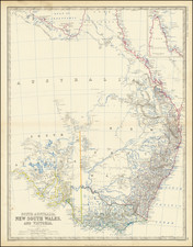
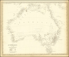
Fine 19th Century Sea Chart of the Indian Ocean and Western Pacfiic, extending from China and New Zealand in the East to Africa in the West, with large inset maps of Hong Kong, Bombay, Port Louis (Mauritius) and smaller maps of Algoa ay, Simon's Bay and several profile Views.
The map includes extensive sailing notes and evidence of early use at sea. Extensive annotations with Australia, along with delineations of the Colony of New South Wales, Colony of South Australia, Colony of West Australia, Australia Felix and other details.
The map bears the imprint of Charles Wilson, successors to Norie & Wilson.
Condition Description
Blue backed chart, with normal signs of use, including some minor soiling and surface abrasions and chipping and a few minor repaired tears.