|
||

|

|
|

|
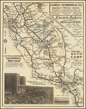
Scarce large format map of the west, showing several transitional and in some cases erroneous western features. Colorado Territory appears, with remarkable Indian and early road details. Several forts, including Vrains, Massachusetts and Pike are noted. The region which will become Wyoming and Montana is identified as Chippewa Territory. Washington Territory still includes all of Idaho and the western parts of Wyoming and Montana. A very small Nevada Territory appears, having not yet benefitted from the anti-Mormon sentiments which would ultimately push its eastern border 2 degrees eastward into Utah Territory. An erroneous western border of Arizona follows the Colorado River to southern Utah. California is oddly mishappen, following the crest of the Sierras and thereby losing the eastern slope, including the Tahoe and Yosemite areas, but extending curiously east to just southwest of Cedar City, Utah. The map is highly detailed throughout, with special emphasis on Indian Tribes and lands, forts, roads, and lakes. Texas includes excellent detail. The color coding notes the free states, slave states and territories. One of the best large format maps of the period.
![[ The Ptolemaic Universe ] Situs Terrae Circulis Coelestibus Circundatae . . .](https://storage.googleapis.com/raremaps/img/small/101512.jpg)