|
||

|

|
|

|
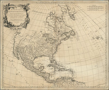
Rare map of the United States, shortly after the Louisiana Purchase, published in Vienna and Budapast.
The map provides a fantastic transitional look at the United States, prior to the Adams Onis Treaty. East Florida and West Florida a still shown, with Georgia extending to the Misssissippi River. Ohio is not yet shown, with the only organized place names west of the Mississippi being Louisiana, New Mexco, Texas and Cuilla.
The course of the upper Missouri River reflects the limited knowledge of the region, being shown in the year of the departure of the Lewis & Clark expedition. The west is dominated by the names of dozens of early Indian Tribes, with only the occasional American, French or English fort noted.
The Illinois Company lands are shown, at the confluence of the Mississippi and Missouri Rivers. Overall, the map provides a nice, if not necessarily accurate, depiction of the topography of the land between the Mississippi River and the Ohio River and in the area of the Great Lakes.
The map is very rare. This is the first example of the map we have ever seen.
![[Whoever is silent is Complicit -- Anti-Vietnam / Anti-American Poster] Vietnam: Sterminio | chi tace è complice](https://storage.googleapis.com/raremaps/img/small/89365.jpg)