|
||

|

|
|

|
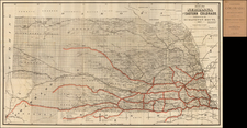
Rare large format promotional map of the State of Nebraska, advertising the lands offered for sale by Andrus's Land Office, at 800 P Street, Lincoln, Nebraska.
The map provides a finely detailed image of Nebraska, colored by counties, and showing U.S. Land Offices, County Seats, Completed Railroads, Towns & Villages, Land District Boundaries, Railroad Land Grant Boundaries, Military Reservations, Indian Reservations, Townships, Creek Beds, San and Sand Hills, etc.
At the lower left corner, the map identifies the certification of the U.S. Surveyor General's Office in Plattsmouth, Nebraska, dated January 20th, 1885 and signed in facsimile by the Surveyor Genral, with a key to the right identifying the 3 Congressional Districts and 10 Judicial Districts in the state.
The full title at the top reads:
One million acres of land in Nebraska, for sale by E.H. Andrus & Son : speculators land, railroad land, state school land, ranches and improved farms in all parts of the state.
The map is very rare. We note only one example, in the Yale Beinecke Collection, along with plainer variant edition, lacking the printed advertising above and below the map, with the Everts imprint at the top right and the name "J.H. Haeifring, lith, 831 Arch St., Phila," at the bottom right corner, (Rumsey Collection, Yale, University of Illinois, and Rutherford B. Hayes Presidential Library).

![A Map of Lewis and Clark's Track Across the Western Portion of North America, from the Mississippi to the Pacific Ocean. By Order of the Executive of the United States in 1804, 5 & 6. . . . [Complete with 3 volumes of Text: Travels to the Source of the Missouri River and Across the American Continent to the Pacific Ocean. Performed by Order of the Government of the United States, in the Years 1804, 1805, and 1806].](https://storage.googleapis.com/raremaps/img/small/81775.jpg)