


|
||

|

|
|

|
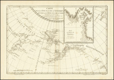
Fine example of the English edition of Lisiansky's map of the area around Sitka and Sitka Sound in Alaska, based upon the surveys of Captain Yuri Federovich Lisiansky in the region at the beginning of the 19th Century.
The map is one of the earliest obtainable maps of the region and one of the few obtainable maps derived from contemporary Russian sources.
Sitka Sound is bordered by Baranof Island to the south and the northeast, by Kruzof Island to the northwest and by the Pacific Ocean to the southwest. During the early 19th century it was a major locus of the Maritime Fur Trade.
As noted by Soliday (describing the book), this map is from a "most important work dealing with discoveries on the N.W. Coast of America. The author was a captain in the Russian navy and commander of the "Neva." He visited Kodiak and Sitka, wintering at the former island, and his long stay there gave him ample time and scope for a study of the native inhabitants and their habits and customs. The long chart shows the track of the voyage, and there are charts of the Washington Islands, Cadiack, and the Harbor of St. Paul, the coast from Bering's Bay to Sea Otter Bay, Sitka or Norfolk Sound, etc.; with colored views of the Harbor of St. Paul in the Island of Cadiack and New Archangel in Norfolk Sound. There are also plates of Indian implements, etc. The work is important also as the principal source for the Sitka Massacre."
![[ California To Alaska -- Northwest Passage ] Quivirae Regnu cum alijs versus Borea](https://storage.googleapis.com/raremaps/img/small/60083.jpg)
![[Bering Land Bridge, Alaska] Teller-Kougarok Area Compliments of Lomen Commercial Company Nome, Alaska](https://storage.googleapis.com/raremaps/img/small/45000jc.jpg)