|
||

|

|
|

|
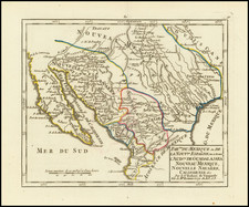
First edition of Bradford's map of the Republic of Texas, the first printed map of the Republic.
Bradford shows the location of a number of the early Mexican Land Grants, Indian Tribes, early roads and towns.
An essential map for Texas collectors, the first edition of the first reasonably obtainable separate map of the Republic of Texas.
Thomas Gamaliel Bradford (1802-1887) was an American geographic publisher. He hailed from Bradford, Massachusetts and began his publishing career by working for the America Encyclopedia. Then, he edited and republished the Atlas Designed to Illustrate the Abridgement of Universal Geography, Modern & Ancient, which had originally been offered in French by Adrian Balbi. In 1835, he published another atlas, A Comprehensive Atlas: Geographical, Historical & Commercial, and, in 1838, An Illustrated Atlas Geographical, Statistical and Historical of the United States and Adjacent Countries. His interests were primarily in educational publishing and he was one of the first mapmakers to show Texas as an independent country.
![[Geology Map of the Texas, California & the Southwest] Esquisse Geologique Des Anciennes Possessions Mexicains Du Nord Incorporees Ala Federation des Etats-Unis . . . 1867](https://storage.googleapis.com/raremaps/img/small/71446.jpg)
![[Manuscript Map and Grant Translation for Adolphe Sterne's Lands in Tyler County, Texas] Translation of Title to One League of Land to Adolfo Sterne [Tyler County, Texas land grant]](https://storage.googleapis.com/raremaps/img/small/85549.jpg)
![(Republic of Texas Land Grants with Maps - Coahuila y Tejas) [Manuscript land grant documents issued by Radford Berry, alcalde of Nacogdoches, to John Adams and others, with manuscript plat maps by Arthur Hendrie and George Aldrich]](https://storage.googleapis.com/raremaps/img/small/88920.jpg)