|
||

|

|
|

|
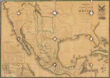
Unrecorded late state of this fine highly detailed wall map of North America, updated to include significant new information in the polar regions of North America.
In addition to the updates in the Polar regions, the map shows the newly independent Mexico and significant revisions in the Midwest and Plains, including a curiously configured Illinois and location of the Northwest Territory. This addition is also the first to show the Adams Onis Treaty borders and a modern border between Canada and the US in the north.
Wheat notes that Brue's map of North America, along with Arrowsmith's map, were the first large format maps to adopt in great detail the official account of the expedition of Lewis & Clark up the Missouri, across the Rocky Mountains and to the Columbia River and the Pacific Ocean. The map is a remarkable amalgam of contemporary cartographic information, reflecting the detailed work and effort by its publisher to compile information from the expeditions of Pike, Lewis & Clark and others for inclusion in this remarkable large format map.
This unrecorded edition of the map has extensive additions and a Note from M. Vivien, stating that the map has been revised to show Admiral Parry's and Franklin's discoveries in the Arctic regions.
The changes in the map are quite profound. The coast of Baffin's Bay has been completely redrawn, with dozens of new place names added. To the west, area called Mer Polaire is a completely new additionk, including the region noted as "Isles de La Georgei Septentrionale." The passage west of the Island of Cumberland or James has largely been eliminated, with tremendous detail along the newly added coastline.
To the north of Slave Lake, an entirely new mountain range has been added, along with some watershed and coastal details on the Arctic Sea, which includes perhaps 4 or 5 times more coastline.
In the region below the Great Lakes, Illinois is now named (and very strangely configured), the Northweat Territory is shown and the old Spanish Land districts west of the Mississippi River are now delineated. Missouri Territory has also been added, as is a revised post-Adams-Onis border between the newly formed Mexico and the United States and the details in Texas and the plains are greatly updated and revised.
This late edition, issued 8 years after the last recorded edition, is a remarkable step forward in the search for the Northwest Passage.
Andre Hubert Brué was a French geographer and cartographer. Born in Paris, he served in the French Navy, joining the Baudin expedition to the Pacific (1800-1804). After his sea service, Brué applied his navigation and charting skills to creating finely-crafted maps, which were renowned for their crisp engraving and accuracy. He drew directly on the copper of the plate, creating what he called encyprotypes. He is best known for the Atlas universal de géographie physique, politique, ancienne et moderne.

![[ Northern Pacific Railroad ] NEW 7-30 GOLD LOAN OF THE Northern Pacific Railroad Co. SECURED BY FIRST MORTGAGE ON RAILROAD AND LAND GRANT. SAFE! PROFITABLE! PERMANENT!](https://storage.googleapis.com/raremaps/img/small/101828.jpg)
![(Strait of Magellan) Freti Magellanici ac novi Freti vulgo Le Maire exactissima delineatio. [The most exact delineation of the Strait of Magellan and the new Strait, commonly known as Le Maire.]](https://storage.googleapis.com/raremaps/img/small/99612.jpg)
![(American Revolution - Spanish Mapping) Mapa Geografico Que Comprehende La Nueva Inglaterra, Nueva York, Nueva Jersey, Pensilvania, Maryland y Parte de Virginia. [Geographic Map Encompassing New England, New York, New Jersey, Pennsylvania, Maryland, and Part of Virginia.]](https://storage.googleapis.com/raremaps/img/small/95136.jpg)