|
||

|

|
|

|
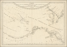
Fine separately issued example of Adolph Lindenkohl's important early map of Alaska, the earliest printed map of lands recently acquired from Russia and the first appearance of the name Alaska on a printed map.
Alaska was purchased from Russia for $7,200,000 on August 1, 1867, a transaction popularly known as "Seward's Folly." In connection with the purchase, the US received from the Russians, a major set of Russian maps, charts, and atlases. These maps included recently published Russian maps and charts, and sets of historic maps dating back to the era of Vitus Bering. Bering, the Danish explorer and cartographer, sailed and mapped for the Russian Empire and had claimed Russian America in the first place.
Originally there were three great land claims to the northern country in play: Great Britain, France, and the Russian Empire. After the defeat of the French in what the North Americans call the French and Indian War (1753-1763), that left Russia and Great Britain as the two claimants for Northwestern America. With Russia's decision to sell Russian America to the United States, the Russian Empire left North America.
The Russian maps received as part of the sale were delivered to George Davidson, who would go on to become one of the most important American mapmakers and scientific minds of the 19th Century. Davidson had been appointed to make a special examination and report upon the geography and resources of Alaska, pending its purchase and his published report and conferences with congressional committees influenced the passage of the bill approving Seward's Folly. Thereafter, Davidson was placed in charge, during 1867, of the work of the Coast Survey on the Pacific, planned work for the land parties from 1868 until 1875, and inspected all the fields of work.
The trove of Russian maps Davidson received, and his party's own reconnaissance in 1867, resulted in the publication that same year of the Survey's first map of the new territory. The geography was new, but the map type was not. During the recent Civil War, the Survey had created entirely new series of territorial maps of the parts of the country where the war was fought, or might be fought, based on a combination of previous maps and original research. The new map was an application of the same processes to the far north of the American continent. Adolf Lindenkohl, whose name appears on the map, was one of the most prolific of the Civil War era mapmakers, whose name appears on many of the most important maps prepared during the War.
The present example is the second edition of the map, which was intended to accompany the Speech of Hon. Charles Sumner of Massachusetts, on the cession of Russian America to the United States (although it is not bound in too many copies).
As noted in Ladd-Mocarski, this map is the "first use on a map of the name Alaska [for all Russian possessions in North America ceded to the U. S.]...The map...was published after the Treaty had been signed, but some months before the actual transfer of Alaska to the U. S. took place."
The second edition adds significant detail not included in the first edition of the map. The second edition is also the first to include the inset map of the area around Sitka and the inset at the top right. The map includes far more topographical detail, much of which is revised from the first edition of the map. The second edition is also the first to add the statistical legend to the right of the scale of miles. The second edition of the map can be seen here: vilda.alaska.edu/cdm/singleitem/collection/cdmg11/id/11932/rec/3
Alaska was purchased from Russia for $7,200,000 on August 1, 1867, a transaction popularly known as "Seward's Folly." The U.S. Flag was raised on October 18, 1867. From 1867 to 1884, the so-called Department of Alaska was under the jurisdiction of the U.S. Army (to 1877), the US Department of the Treasury (1877-79) and the US Navy (1879-1884). Thereafter, it became the District of Alaska until 1912, when it became a Territory of the United States.
The present example is unfolded, and was apparently issued separately.
Both editions of the map are very rare on the market. We have not located another example of the map offered at auction or in a dealer catalog in the past 30 years.
![[Havana / Cartagena] Neu und Verbesserter Plan der St. u. Hafens Havana aus der Ins. Cuba . . . 1739 [with] Neu under verbesserter lan des Hafnes non Cathaagena in America . . . 1740](https://storage.googleapis.com/raremaps/img/small/89441.jpg)
![(Nothern Half) [Bancroft's Map of the Pacific States]](https://storage.googleapis.com/raremaps/img/small/54924.jpg)