


|
||

|

|
|

|
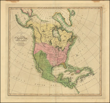
Extremely rare 1699 example of Nicolas Sanson's maps of North America and South America, printed on a single sheet, the latter of which providing credit to Pierre Moullart Sanson.
This is the rare transitional map between, where Pierre Moullart Sanson begins to significantly revise his Grandfather's map of North America, modifying perhaps the three most noteworthy features of Sanson's prior maps of North America (the Island of California, open ended Great Lakes and the course of the Mississppi River).
Notably, this map pre-dates the change to California. In the 1705 (and later 1726 editions, based upon the recent reports from Fra. Eusebio Kino and likely in conjunction with manuscript maps by Guillaume De L'Isle and Nicholas De Fer), California was definitively re-attached to the mainland, with an annotation in French noting that it is now believed that California is joined to New Mexico. Burden notes that the 1705 edition of the map is one of the earliest to rejoin California to the mainland.
This 1699 edition is the first in which Moullart-Sanson radically re-casts the Mississippi River, adopting the model shown in pre-1700 manuscript maps by De L'Isle and the extremely rare first edition of De L'Isle's map of North America, which shows the Mississippi flowing into the Gulf of Mexico just north of the Rio Grande River, in modern day Texas. Only a few known examples of the first edition of De L'Isle's 1700 map of North America show this unusual river course, which dates to models of the Mississippi which De L'Isle was working with in manuscript form in the years before his first printed map of the region. The curious confluence of rivers near modern day New Oreans and the the mouth of the Mississippi are no longer shown and in its place, a shortlived northeasterly river is shown, more or less below the Ohio River. Most of the other rivers along the Gulf Coast have been elmininated.
The final noteworthy change to occur in 1699 is the updating of the Great Lakes, reflecting an adaptation of the information from Coronelli and later 17th Century French Sources. The west end of the lakes are now closed, unlike earlier editions.
There is one other change which appears for the first time in this 1699 edition. The Rio Grande is now shown flowing into the Gulf of Mexico, whereas in earlier editions, the river flows into the Sea of Cortez. Cibola, Quivira and Conibas are also removed in this edition of the map for the first time.
These late Moullart-Sanson maps are quite rare. Neither Burden nor McLaughlin were aware of the existence of this 1699 edition of the map and we are not aware of another example appearing on the market. Burden was unable to locate an example of the 1705 edition of the map and relied upon this 1726 edition for his description.
The present map is clearly a transitional map between the 1657 first state and the 1705/1726 states. of the map. California remains shown as an Island, with Terre de Iesso shown to the West. A number of northern lakes are shown above the Mississippi River, with Hudson's Bay dramatically reshaped. The reference to New Amsterdam and Nouvelle Pays Bas (New Netherlands) has been removed from the map for the first time.
Further south, in addition to modifying and significantly improving the depiction of the Mississippi and Ohio Rivers, there are a number of new place names in Florida and the Southeast.
In the final edition, the reference to Terre de Iesso and the partial coastline below are removed and the note joining California to the mainland is added.
The present example is from the personal collection of Glen McLaughlin, having been acquired after publication of his Mapping of California as an Island.
The appearance of the two maps on single sheet suggests they may have been a proof sheet or perhaps bound into a composite atlas.
![[ Southern California to Grand Canyon / Boulder Dam ] Inexpensive Sky Tours via Western Air Express](https://storage.googleapis.com/raremaps/img/small/76820.jpg)
![[ The Ptolemaic Universe ] Situs Terrae Circulis Coelestibus Circundatae . . .](https://storage.googleapis.com/raremaps/img/small/101512.jpg)