This item has been sold, but you can enter your email address to be notified if another example becomes available.


|
||

|

|
|

|
Stock# 33381
Description
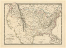
Rare and historically significant map of the proposed route for a road from Washington to Lake Ontario, which was separately issued in connection with a bill submitted to Congress. The map was intended to illustrate a rare report, published in 1827.
The map covers all or parts of Maryland, Pennsylvania and New York and shows the routes considered for the proposed National Road.
Detail such as topography, cities and towns appears only in the areas along the proposed routes.
The map is very rare on the market, with no examples listed in AMPR in the past 30 years.
Condition Description
2 sheets joined. Flattened and archivally backed to support folds splits, etc.
Reference