


|
||

|

|
|

|
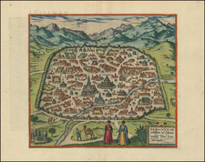
Rare map of the Holy Land, published by Gerard de Jode in Antwerp in 1571.
The map notes that it is drawn after a map by Peter Laicstain, published in Germany in 1570. De Jode's map was in turn copied by Braun & Hogenberg in their first map of Jerusalem and by Francois de Belleforest in the French edition of Munster's Cosmographia. As noted by Laor:
A topographic plan of modern Jerusalem oriented to the east. . . .These pictures of ancient and modern Jerusalem were published in Calcar by Vincentius Houdeaen in 1570. Today they are quite a rarity and much sought after. Here they are printed after the model by Gerardus de Jode in Antwerp. Th plans published by Houdaen in Calcar are those of Laicstain, but today, no copy is extant.
Laicstain, a Dutch geographer, had visited Jerusalem in 1556 and subsequently created a number of sketches on during his travels.
Gerard De Jode (1509-1591) was a pre-eminent mapmaker in the late seventeenth century, a time when the Dutch dominated the map trade. He was known for his many maps, some of which featured in Speculum Orbis Terrae (first edition Antwerp: 1578). Although never as successful as Ortelius’ Theatrum, the Speculum did get republished in a second edition in 1593, two years after De Jode’s death, by Arnold Coninx, and included this map. After his death, Gerard’s son, Cornelis (1568-1600), and his wife, Paschina, ran the shop. Unfortunately, Cornelis died young in 1600, aged only 32, and the stock and plates were sold to the publisher Joan Baptista Vrients.
![A view of the division of the land of Canaan and the situation of the city and sanctuary [Manuscript map]](https://storage.googleapis.com/raremaps/img/small/87556.jpg)
![[ Gifted To Cecil B. De Mille by Elmer Bernstein ] (Mortier Bible) Histoire du Vieux et du Nouveau Testament Enrichie de plus de quatre cens Figures En Taille-Douce, &c. [2 vols in 1]](https://storage.googleapis.com/raremaps/img/small/96625.jpg)