|
||

|

|
|

|
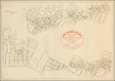
The Route Map Through California For Anza's Second Expedition
Finely executed manuscript map of Southern California and neighboring parts of Baja California, Southern Arizona and Sonora, showing tracks of the second expedition of Juan Bautista de Anza (1775-76), the first major expedition which brought Colonists from Mexico to Alta California.
This remarkable manuscript map was drawn to illustrate the manuscript diary of Pedro Font, who maintained the official report and account of De Anza's second expedition. The map shows daily progress of the trek of Anza's expedtion through part of the coastal regions of present-day Southern California and Southern Arizona, extending south into Baja California and part of Sonora. Pedro Font accompanied Anza on his second expedition and his diary is the primary historical source for what is known about Anza's second expedition, the first Spanish overland expedition to bring colonists to the Missions of Upper or Alta California.
This example of the map shows day 1 to day 81 and day 113 to day 144 of Anza's trek through Southern California towards San Francisco, before the lost upper left panel obscures the rest of the expedtion. A similar manuscript map in the collection of the John Carter Brown Library shows the full expedition: jcb.lunaimaging.com/luna/servlet/detail/JCBMAPS~1~1~2131~109410008:C-0155
The map tracks the progress of Juan Bautista de Anza's second trip into California, from its start in Sonora at the the Mission San Miguel Arcángel de los Ures (south of the Sonora River not far west of its big bend from a southerly to southwesterly course toward Hermosillo and the Gulf of California) to San Francisco (via Mission San Gabriel and Mission Santa Barbara), including a side trip to Mission San Diego from San Gabriel. Cartographic elements include lines of latitude and longitude, scale, sea banks or shoals, some topographical details, location of roads, presidios, churches, and the daily log of encampments along the route.
Following the creation of the first missions in Alta California in 1769, the Spanish recognized the need to establish a reliable land route to Alta California. In 1772, Juan Bautista de Anza proposed an expedition to the Viceroy of New Spain. With a small expedition party, Anza treked northward from Sonora to the Gila River, then on the the Mission San Gabriel and finally to Monterey from January 8, 1774 to April 19, 1774.
Following this successful first expedtion, a larger second expedition was organized. The second expedition, including Father Pedro Font and a group of colonists, departed for California in October, 1775, reaching the Mission San Gabriel in January 1776. After settling the colonists in the Southern California Missions, Anza and a smaller group (including Pedro Font), travelled north to San Francisco, locating the first overland route to San Francisco Bay.
As shown on the map, before making the trip north, Anza and a small group of men proceeded south to the Mission San Diego, where the Indians had recently attacked the mission, killing Father Juame and two Spanish workmen. Anza decided to travel to San Diego to render assistance, and also to seek additional supplies for the journey to Monterey, since the colonists were straining the resources available at San Gabriel.
In describing the John Carter Brown copy of the map it was noted that:
[Pedro] Font trained at the College of the Holy Cross of Querétaro, Mexico, and was assigned to the Mission San José de Pimas in Sonora, New Spain. Because of his expertise with navigational equipment, he accompanied Juan Bautista de Anza on a trek to Alta California from the Tubac Presidio. His diary, the extended version of which is at the John Carter Brown Library, is considered the best account of Anza's expedition to establish a Spanish base on the North American west coast. . . .
The present example of the map is a contemporary copy of Font's original map, almost certainly drawn shortly after a copy of the original Font manuscript map and diary reached Madrid, almost certainly sometime between 1777 and 1780. Other copies are held by The John Carter Brown Library and the Archivo General in Mexico City (as described in 1871 by Manuel Orozco y Berra, one of Mexico's leading 19th Century indigenous cartography scholars). The watermark of D & C Blauw appears on the map and is known to have been used in the middle and later part of the 18th Century. For example, D & C Blauw watermarked paper was used by Thomas Jefferson for some of his architectural drawings and on other late 18th Century Spanish manuscript maps.
This copy of the map was found in a composite atlas of Spanish maps which was divided up in 2012, after being acquired by the Old Print Shop in New York City from Clive A. Burden Ltd. A number of the maps were subsequently acquired by us in February 2013. The contents of the atlas included manuscript maps and Spanish printed maps, which included maps of northern coasts of South America, Mexico and California, along with maps Spanish maps of the Caribbean, Balearic Islands and northern coastline of Spain. The maps in the atlas dated from the early 18th Century to approximately 1780 and included several other remarkable manuscript maps, including a remarkable early 18th Century pictographic map of the road from La Paz to Lima: /gallery/detail/33348
In the second half of the 18th Century, the Spanish ended the near absolute embargo on printed maps of the New World, While printed maps began to appear through mapmakers such as Tomas Lopez by the 1760s, the practice of creating manuscript copies of other manuscript maps was still quite common in Spain in the late 18th Century, especially in regions such as California, where there was little demand for printed maps. The present map, drawn from a composite atlas of other printed and manuscript maps, was almost certainly assembled for someone with significant commercial or similar interests in the New World, as demonstrated by the elaborate pictographic map illustrated above.
While manuscript maps of California appear periodically on the market, virtually all such maps are smaller regional maps, depicting the entirety of the California Mission system, and are typically maps coming from Jesuit and Franciscan archives. Similar to the map shown here: /gallery/detail/33351
This is the first contemporary 18th Century manuscript map of California we have seen on the market which which illustrates the route of an important contemporary expedition, rather than having been drawn from an ecclesiastic archive.
![[Southern Arizona - Sonora] (Restricted) Douglas . . . Sectional Aeronautical Chart](https://storage.googleapis.com/raremaps/img/small/96226.jpg)