|
||

|

|
|

|
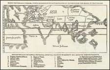
Fine example of Adam Freidrich Zurner's scare double hemisphere map of the World, embellished with 26 decorative scenes and scientific projections of the Celestial skies and contemporary astronomical theories and teachings.
Zürner's work is relatively unknown, appearing usually in other publishers' atlases, such as Schenk's Atlas Contractus.
An attractive and interesting map full of detail including most of the coast of Australia, the western coast of New Zealand, and the routes and discoveries of exploreres Magellan, Dampier ("Nova Britannia" in 1700), Tasman, Gaetani and Chaumont. Surrounding the map is an elaborate border showing winds and climates, and along the bottom edge a panorama illustrating tempests, earthquakes, tides, vortices, and a textual commentary on all the natural phenomena illustrated.
California is shown as an island, but very tentatively so, with the coloring suggesting that it may be a peninsula, suggesting early knowledge of Fra. Eusebio Kino's observations from California.
Adam Friedrich Zürner (15 August 1679 – 18 December 1742) was a German Protestant priest, cartographer and the head of construction of the Kursächsische Postmeilensäulen in Saxony.
Zurner's first project of note was a map of Saxony, for which he was retained by August III, King of Poland, in 1711.
Zurner was appointed Geographer of Poland and the Electorate of Saxony, a position in which he served until 1732. In this time period, he reportedly traveled nearly 18,000 miles and created over 900 maps.
In 1721, he was tasked with establishing a postal road system in Saxony and marking the distances with stone posts.
His work resulted in the Atlas Augusteus Sauronicus (40 maps plus key sheet), which remained incomplete until after Zurner's death, but was ultimately sold to Pieter Schenk in Amsterdam in about 1745. Schenk's completed work (49 maps, published in Amsterdam and Leipzig) was issued without reference to Zurner's name, under the title Atlas Saxonicus.
Despite his prolific work product, none of Zurner's original manuscript maps seem to survive.


![[ Game Board World Map -- Gulf of Korea named ] Walker's Geographical Pastime Exhibiting a Complete Voyage Round the World in Two Hemisphere with Tetotum, Pillars & Counters, for Playing This Highly Interesting Game.](https://storage.googleapis.com/raremaps/img/small/102691.jpg)
![[ Mapping The World's Telegraph Lines ] Planisphere Terrestre Indiquant Les Lignes Modernes de grande Communication par terre et par me Chemins De Fer - Paquebots-Telegraphie Electrique. . . . 1878](https://storage.googleapis.com/raremaps/img/small/98800.jpg)