|
||

|

|
|

|
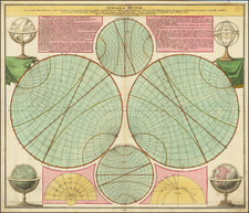
The second known example of this extraordinary broadside illustrating the Total Solar Eclipse of 1724, including a World map featuring the expected track of the eclipse over the earth's surface.
This rare and broadside illustrates the Total Solar Eclipse of May 22, 1724 that passed directly over southern England and Wales, and was issued shortly before the event occurred. The work was engraved by Emanuel Bowen and issued by Thomas Bowles from his shop near St. Paul's Cathedral in order to capitalize on the contemporary fascination with astronomical phenomena. This level of popular interest arose upon Edmund Halley, the Astronomer Royal's observation of Halley's Comet in 1705 and his efforts to promote awareness the of the Solar Eclipse of 1715. Indeed, many publications were produced to illustrate and explain the 1715 event, which ensured that the expected 1724 eclipse was eagerly anticipated.
The full title of the work reads:
A Plain Description, of the Increase and Decrease of the Great Eclipse of the Sun, that will happen on the 11th. day of May 1724. Whereunto is added, a map of the world shewing what places [the] center of the shade will pass over, from its beginning at sun rising, to its end, at sun setting. Its motion is esteem'd to be 4 times swifter than a cannon ball (continuing [the] muzzle same degree of velocity, as when it leaves [the] muzzle of [the] cannon) which is about 2000 miles in an hour.
The present broadside was issued in the days immediately leading up the expected Full Solar Eclipse, which was set to occur in May 11, 1724 (Old Style, Julian calendar), which corresponds to the date of May 22 on our modern Gregorian calendar (which was only adopted in Britain in 1752). The series of 25 diagrams that make up most of the upper two-thirds of the work depict the rare occurrence when the Moon on its orbit passes directly between the Earth and the Sun, such that the Moon's apparent diameter is larger than the Sun, blocking all direct sunlight, thus turning day into darkness. Importantly, a Total Eclipse occurs in a narrow path across the surface of the Earth, while a partial solar eclipse will be visible over a region thousands of miles wide.
The double-hemisphere World map that occupies the lower third of the map, identifies the predicted circuit of the Total Eclipse by way of a red line. The course, as forcasted by Halley, is picked up in southern Italy and runs the length of that peninsula, before traversing France. Fortunately for Britons, its path continued to run diagonally through southern England (passing just south of London) and southern Wales, while much of the rest of England, Wales and Ireland was still treated to a nearly full spectacle. In North America, the path arrived at Labrador, crossed the content, before arriving over the Pacific at Baja California (California is notably shown to be an island). Contemporary observers were fascinated by the speed of the Eclipse, which was, as noted in the broadside's title, was said to be "4 times swifter than a cannon ball", or to travel approximately "2000 miles in an hour".
The present broadside is exceedingly rare. We are not aware of any other examples appearing in dealer's catalogs or at auction in the last 25 years. We are aware of one example in institutional collections, being at Harvard University's Houghton Library.
Provenance: The Collection of Mr. Glen McLaughlin, California, U.S.A.
Emanuel Bowen (1694?-1767) was a British engraver and print seller. He was most well-known for his atlases and county maps. Although he died in poverty, he was widely acknowledged for his expertise and was appointed as mapmaker to both George II of England and Louis XV of France. His business was carried on by his son, Thomas Bowen. He also trained many apprentices, two of whom became prominent mapmakers, Thomas Kitchin and Thomas Jeffreys.

![Globi Coelestis In Tabulas Planas Redacti Pars IV . . . [Virgo, Leo, Hydra, Libra etc.]](https://storage.googleapis.com/raremaps/img/small/70892.jpg)