


|
||

|

|
|

|
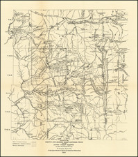
Highly detailed map of Cochise County, compiled H.C. Howe, Cochise County Surveyor and published by Rand McNally.
The present map is almost certainly the first printed map of Cochise County, then a booming mining and ranching area in Arizona Territory, published only a few years after the Gunfight at the OK Corral, in Tombstone.
At the time of the publication of the map, Tombstone as the largest town and the County Seat of the newly formed county, which was adjacent to the Tombstone Mining District. Only three railroads are shown, the Southern Pacific Railroad, The Sonora Railroad and the Arizona & Southeastern Railroad, whose line extended from Benson and Fairbanks to Warren and the Bisbee MIning District.
The map also shows several early Mexican And Grants. The Harford Mining District, Winchester Mining District, California Mining District, and Swissholm Mining District, Turquois Mining Distrct are located. Fort Bowie is shown, as is a Customs House south of the Border in Sonora, which would likely later become the Naco Customs House (not shown on the map). There are a remarkable number of small settlements, ranches and springs located on the map, given that the entire population of the County in 1890 was about 7,000 residents.
Cochise County was created on February 1, 1881, from the Eastern portion of Pima County. The present map would appear to be the only map of Cochise County published prior to 1900, with the next earliest map of the county being published in 1904 in Tombstone.
OCLC locate two examples of the map, one in the Arizona Historical Society Collection and the other at the University of Arizona, which dates the map as "1880-1890?" ).
Rand McNally & Co. is a large American map and navigation company best known for its annual atlases. The company got its start in 1856, when William Rand opened a print shop in Chicago. He was joined in 1858 by a new employee, Andrew McNally. Together, the men established their namesake company in 1868. Originally, the company was intended to print the tickets and timetables for the trains running to and through Chicago; their first railway guide was published in 1869.
By 1870, they had shifted from just printing to publishing directories, travel guides, and newspapers. Their first map appeared in 1872 in a railway guide. The map was produced using a new wax engraving method, a cheaper process that gave the company an edge.
By 1880 Rand McNally had entered the education market with globes, wall maps, and geography texts for students. In 1923, Rand McNally published the first Goode’s World Atlas, named after its editor, Dr. J. Paul Goode. For generations afterward, this would be the standard classroom atlas.
In 1899, William Rand left the company, but McNally and his family remained, controlling the company for over a century. In 1904, they published their first road map intended for automobiles and by 1907 were publishing Photo-Auto Guides, which combined photography and mapping to help drivers. In 1924, they produced the Auto Chum, a precursor to their famous road atlases. Rand McNally would remain the leader in road maps and atlases throughout the twentieth century.
In 1937, Rand McNally opened its first store in New York City. Ever on the frontier of technology, Rand McNally pioneered the scribing process for printing tickets in 1958 and printed their first full-color road atlas in 1960. Arthur Robinson developed his now-famous projection of Rand McNally in 1969. By the 1980s, the company was exploring digital reproduction and digital databases of maps for truckers. In the 1990s, they lead the charge to develop trip-planning software and websites. Today, most of its products are available online or in a digital format, including maps for tablets and phones.
![Map of the Missouri Pacific and St. Louis, Iron Mountain and Southern Railway and Connections [Missouri Pacific Railway. St. Louis & All Points East Chair Cars Free Fast Mail Route]](https://storage.googleapis.com/raremaps/img/small/91606.jpg)


![[California, Texas, and Southwest Globe Gore] with [Strait of Anian Globe Gore]](https://storage.googleapis.com/raremaps/img/small/99425.jpg)