


|
||

|

|
|

|
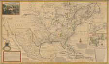
Important early detailed map of the interior part of North America, including California as an island, by Herman Moll.
Moll's map was originally published in 1718, following the publication of Delisle's 1718 map of the Mississippi Valley. Although Moll appears at first to copy Delisle's 1718 Carte de la Louisiane et cours du Mississipi . . ., Moll actually enlarges Delisle and attacks the veracity of the French claims in America as reflected in Delisle's map. As noted by Cumming
Moll calls upon the English noblemen, gentlemen, and merchants interested in Carolina to note the 'Incroachments' of the French map on their 'Properties' and on the land of their Indian allies. The map presents details of the Southeast found in no other printed map. The chief source of this information is a large, unsigned, undated manuscript map in the Public Record Office, from which Moll took much information on trading paths, Indian tribes, French, Spanish, and English forts and settlements, rivers, and other topographical data."
In The Mapping of the American Southwest, Reinhart notes
Moll's mapping of Texas and northern Mexico is both informative and appealing. He was best at coastal geography, depicting with some accuracy the coastal features, barrier islands (e.g., Padre Island), and identified rivers emptying into the Gulf of Mexico. The rivers often continue deep into the interior, where there is less detail, but Moll does indicate various Indian tribes.... But most intriguing are Moll's notations. For example, he mentions several times the Spanish cattle gone wild the famous Texas longhorns of later years by noting 'Country full of Beeves' or 'This Country has vast and Beautiful Plains, all level and full of Greens, which afford Pasture to an infinite number of Beeves and other Creatures' in East Texas near the 'R. Salado.' Nearby also is noted, 'Many Nations [of Indians] on ye heads of this Branches [of several rivers] who use Horses and Trade with the French and Spaniards.'
Moll voraciously defends the English claim to the territory east of the Mississippi and gives back part of Florida to Spain; in the Advertisement text, Moll states: All within the Blew Colour of this Map, shows what is Claim'd by France under the Names of Louisiana, Mississipi &c. According to a French Map published at Paris with the French King's Privelege. The Yellow Colour what they allow ye English. The Red, Spain....
The map is one of four large maps of North America by Moll, which distinguished him as the leading English mapmaker of the early 18th Century. The present edition lists the names of Moll, John King, Thomas Bowles and John Bowles.
Herman Moll (c. 1654-1732) was one of the most important London mapmakers in the first half of the eighteenth century. Moll was probably born in Bremen, Germany, around 1654. He moved to London to escape the Scanian Wars. His earliest work was as an engraver for Moses Pitt on the production of the English Atlas, a failed work which landed Pitt in debtor's prison. Moll also engraved for Sir Jonas Moore, Grenville Collins, John Adair, and the Seller & Price firm. He published his first original maps in the early 1680s and had set up his own shop by the 1690s.
Moll's work quickly helped him become a member of a group which congregated at Jonathan's Coffee House at Number 20 Exchange Alley, Cornhill, where speculators met to trade stock. Moll's circle included the scientist Robert Hooke, the archaeologist William Stuckley, the authors Jonathan Swift and Daniel Defoe, and the intellectually-gifted pirates William Dampier, Woodes Rogers and William Hacke. From these contacts, Moll gained a great deal of privileged information that was included in his maps.
Over the course of his career, he published dozens of geographies, atlases, and histories, not to mention numerous sheet maps. His most famous works are Atlas Geographus, a monthly magazine that ran from 1708 to 1717, and The World Described (1715-54). He also frequently made maps for books, including those of Dampier’s publications and Swift’s Gulliver’s Travels. Moll died in 1732. It is likely that his plates passed to another contemporary, Thomas Bowles, after this death.
![(American Revolution - Spanish Mapping) Mapa Geografico Que Comprehende La Nueva Inglaterra, Nueva York, Nueva Jersey, Pensilvania, Maryland y Parte de Virginia. [Geographic Map Encompassing New England, New York, New Jersey, Pennsylvania, Maryland, and Part of Virginia.]](https://storage.googleapis.com/raremaps/img/small/95136.jpg)
![[United States Independence After The Revolution] A New Map of North America, with the West India Islands, Divided according to the Preliminary Articles of Peace, Signed at Versailles, 20 Jan. 1783, wherein are particularly Distinguished The United States, and the Several Provinces, Governments &ca, which Compose the British Dominions . . . 1783](https://storage.googleapis.com/raremaps/img/small/70734.jpg)