


|
||

|

|
|

|
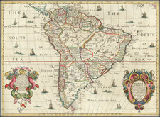
Fine example of Gerard Valk's monumental 8-sheet wall map of the Americas, commemorating the Glorious Revolution.
This masterpiece represents one of the finest achievements of the golden era of Baroque cartography in the Netherlands. The New World, meticulously engraved, appears within a grand tableau of sumptuous allegorical adornment, enlivened with fine original color. Cartographically based on Frederick De Wit's wall map of 1672, Valk's work was engraved on new plates and features original artistic decoration. California is shown to be an island, featuring the 'double bay' motif, after Luke Foxe's 1635 map. The Pacific Northwest is entirely absent, while further to the east, the delineation of Hudson's Bay evinces the discoveries of Thomas James in 1631-2. The Great Lakes remain enigmatic, and the depiction of the Mississippi basin predates the adventures of La Salle. Conversely, much of Mexico and the Caribbean is featured in great detail. The delineation of South America is comparatively well-assured, although the Amazon is erroneously shown to connect with the headwaters of the Río de la Plata.
The upper right corner features an inset of the Arctic Circle encompassed by a pageant of festoons, putti and deities. The map contained within hails from Henricus Hondius's polar projection of 1636. Decoratively, the interior of South America is inhabited by scenes of native peoples and exotic animals, while numerous ships traverse the oceans, including two naval battles scenes in the Atlantic. Both of the lower corners are inhabited by vivid allegorical scenes. The scen on the left shows the personifications of war and knowledge flanked by vignettes of European encounters with indigenous warriors. The scene on the right depicts a procession of elaborately-attired native peoples along with a Peruvian llama.
All such wall maps are great rarities. Technically difficult and very expensive to produce, they were issued in very limited quantities. Moreover, their great size and the manner in which they were displayed made them especially vulnerable to damage, such that very few examples survive to the present day. Importantly, the present map has been preserved in remarkably fine condition for work of its genre. It is highly likely that only a few copies of Valk's wall map of the Americas are extant. Philip Burden cites only two examples held by institutions, one at the British Library (London) and the other at Servicio Geográfico del Ejécito (Madrid).
The present example is from the Glen McLaughlin Collection, which was featured in the Mapping of California as an Island, although the map does not appear in McLaughlin's book, as it was acquired subsequent to the publication of the map and was, at the time, unknown to McLaughlin. The present example was used by Burden to illustrate his entry on the map and is almost certainly the finest extant example (and only 1 of 2 known examples to include the extra title panel at the top of the map).
During the 17th century, when the Dutch Republic was at its economic and cultural high point, monumental wall maps possessed a unique and prominent role which transcended the realm of cartography. They were considered to be among the ultimate signs of intellectual sophistication and affluence, notions of great import to the ruling mercantile class of the Netherlands. Their iconographic significance was best captured by Johannes Vermeer, who prominently featured wall maps in several of his paintings.
The story surrounding the publication and dissemination of Valk's wall map of the Americas is especially fascinating. In 1685, James II became the King of England and of all British dominions, but soon found himself almost universally despised by his own subjects due to his heavy-handed manner and his religious affiliation. In 1688, in what would be celebrated as the 'Glorious Revolution', William of Orange-Nassau, the Stadhouder of the Netherlands and the husband of James's estranged daughter Mary, mounted a successful invasion of England. As William III, he formed a co-monarchy with Mary, and presided over a period of profound economic reform and military success. Notably William's ascension enabled a cultural and intellectual exchange, in which many aspects of the Netherlands' pre-eminence in finance, science, publishing, ship-building, architecture and the fine arts were transferred to Britain.
In this light, Valk produced the Nova Accurata Totius Americae Tabulae specifically with the English market in mind. As such a grand production was far beyond the abilities of virtually all local mapmakers, it must have made an extraordinary impression upon its arrival in London. The elaborate allegorical montage in the lower left corner features a portrait of William III within a laurel wreath interlaced with a bright orange ribbon, the signature color of the House of Orange. The savvy Valk, seeking to capitalize on the overwhelming popularity of the Revolution, devised this celebration of William's ascension and England's colonial ambitions in the New World.
At the time that this map was published, Gerard Valk was on the ascendency towards becoming the premier map and globe-maker in the Netherlands. Interestingly, in the 1670s he worked in London where he would have gained vital contacts and an appreciation of the English market, making him the ideal figure to devise the present 'crossover' map. Following his return to Amsterdam, in 1680, he formed an alliance with his future brother-in-law Petrus Schenk. They acquired the plates for Jansson's Novus Atlas, which formed the basis for the lucrative production of folio maps. In the late 1680s, Valk had refined his skills and marshalled the resources necessary to produce a select series of wall maps of the world and continents, including the present example. Around 1700, Gerard, joined by his son Leonard, began to produce globes, which came to be considered the finest such works of their time. In 1708, Valk and Schenk famously published an edition of Andreas Cellarius's Harmonia Cosmographica. The family business continued to thrive under the leadership of Leonard and his wife Maria until the 1750s.
Gerard Valk, or Gerrit Leendertsz Valck (1652-1726) together with his son Leonard, were the only significant publishers of globes in the Netherlands in the eighteenth century, enjoying an almost total monopoly in the first half of the 1700's. Initially an engraver and art dealer, and having worked for map-sellers Christopher Browne and David Loggan in London between 1672 and 1679, Valk established the firm in Amsterdam in 1687. Initially, they published maps and atlases, but in 1700 the company moved the shop to the building previously occupied by map and globe-maker Jodocus Hondius. In 1701, he applied for a charter for making globes and the "Planetolabium", designed by Lotharius Zumbach de Coesfelt (1661-1727), an astronomy lecturer at Leiden University. The Valks produced several editions of 3, 6, 9, 12, 15, 18 and 24-inch diameter terrestrial and celestial globes. The cartography, as stated on the cartouche, is based closely on the celestial atlas Uranographia, published in 1687 by the celebrated Polish astronomer Johannes Hevelius (1611-1687).
Around 1711, when he became a member of the bookseller's guild, Leonard Valk (1675-1746) came into partnership and his name started to appear alongside that of his father on the cartouches of the globes, although the earliest of these, both terrestrial and celestial, still bear the date 1700. Leonard naturally took over the business on his father's death in 1726, and following his own death in 1746 the firm was run by Maria Valk, cousin, and wife to Gerard. By then its days of glory had passed. Leonard Valk died in relative poverty: his wife had to take in the washing of their aunt to make ends meet. The late eighteenth century saw a number of successful reissues by publisher Cornelis Covens (1764-1825), who ran the famous cartographical publishing house of Covens & Mortier (1721-1866) in Amsterdam. This firm was the biggest Dutch one for publishing maps in the 18th century. It was located on the Vijgendam (Fig Dam), the southern part of what is now Dam Square, the central hub of the city. They didn't move out of their building, but they did change addresses. At first in 1795 the whole Dam was rebaptized into Revolution Square, then it got the name Napoleon Square, till in 1813 after Napoleon's fall Covens & Mortier were back again at the Vijgendam.
![Pascaart vertoonende de zeecusten van Chili, Peru, Hispania Nova, Nova Granada, en California…. [Early New Zealand Inset]](https://storage.googleapis.com/raremaps/img/small/65168.jpg)

![[ Chinese Voyages To America, etc. ] Memoires De Litterature, Tires Des Registres De L'Academie Royale Des Inscriptions et Belles-Lettres Depuis l' annee M. DCC. XVIII. julques & compris l'annee M. DCC. XXV Tome Quarante-Neuvieme](https://storage.googleapis.com/raremaps/img/small/101296.jpg)
![A New Mapp of America Septentrionale . . . 1669 [California shown as an island]](https://storage.googleapis.com/raremaps/img/small/94304.jpg)