The item illustrated and described below is sold, but we
have another example in stock. To view the example which
is currently being offered for sale, click the
"View Details" button below.
![[ Japan ] Royaume du Iapon. Designe par le Pere Ph. Briet de la Compagnie de Iesus . . . By Philip Briet / Pierre Mariette](https://storage.googleapis.com/raremaps/img/small/75238.jpg)
1667 circa Philip Briet / Pierre Mariette
$ 1,600.00


|
||

|

|
|

|
Stock# 33094
Description
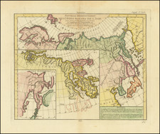
Striking early map of Japan and Korea.
Briet's map follows the Blancus/Moreira model, and looks very similar to the Christophoros Blancus unpublished map of 1617. The map shows a well-shaped Japan with named provinces, and major cities including Tokyo (Yendo) and Kyoto (Meaco). Kyushu and Shikoku are shown with exaggerated inlets, and the tip of Hokkaido is Terre de Iesso. Korea is described as an island, but is only partially shown.
Reference
Walters #32, OAG 31; Cortazzi, Isles of Gold #67.
![[Officials Assigned to Defence Duty along the Shore in Nagasaki] [Nagasaki kaigan okatame oyakunin]](https://storage.googleapis.com/raremaps/img/small/55552.jpg)
![[ First State of the First Map of America ] Novae Insulae XVII Nova Tabula](https://storage.googleapis.com/raremaps/img/small/94609.jpg)