This item has been sold, but you can enter your email address to be notified if another example becomes available.


|
||

|

|
|

|
Stock# 3297
Description
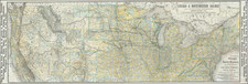
Scarce large map, showing remarkable topographical detail in the west. Includes up to date roads, railroads, mountains, rivers, towns, forts, Indian Villages and information, etc. Only Oregon, Washington, Utah, New Mexico and California west of the Rockies. Nebraska runs north to Canada. Kansas takes up much of Colorado. Minnesota Territry extends west to the Missouri. Fabulous detail in Western Canada. An excellent post Gadsden Treaty mapping of the US Western Territories.