This item has been sold, but you can enter your email address to be notified if another example becomes available.


|
||

|

|
|

|
Stock# 32952mb
Description
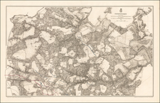
Scarce early battle plan showing the troop positions around Fort Henry and Fort Donelson, between the Tennessee River and Cumberland River.
Includes fortifications in red, roads, rivers, telegraph lines and other topographical details.
Reference
Stephenson, R.W. (CW) 1st ed., 415.
![[ Emancipation Proclamation] The First Reading of the Emancipation Proclamation Before the Cabinet](https://storage.googleapis.com/raremaps/img/small/93789.jpg)
![[ Cherokee Nation ] A Map of the Tennassee Government formerly Part of North Carolina from the latest Surveys. 1795.](https://storage.googleapis.com/raremaps/img/small/100899.jpg)
![(Three Days at Gettysburg) Map of the Battlefield of Gettysburg July 1st, 2nd, 3rd 1863. . . [Three Maps]](https://storage.googleapis.com/raremaps/img/small/101769.jpg)