
This item has been sold, but you can enter your email address to be notified if another example becomes available.


|
||

|

|
|

|
Stock# 32952mb
Description
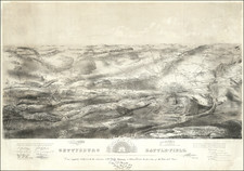
Scarce early battle plan showing the troop positions around Fort Henry and Fort Donelson, between the Tennessee River and Cumberland River.
Includes fortifications in red, roads, rivers, telegraph lines and other topographical details.
Reference
Stephenson, R.W. (CW) 1st ed., 415.


![[ Vicksburg Battle Plan ] Map Illustrating The Operations of the U.S. Forces Against Vicksburg.](https://storage.googleapis.com/raremaps/img/small/60302.jpg)