


|
||

|

|
|

|
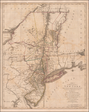
Important early Revolutionary War map, published by William Faden shortly after the signing on the Declaration of Independence.
This remarkable map is a combination of two of the most important colonial surveys conducted on the eve of the Revolution, combining Claude Sauthier's manuscript map of New York with Berard Ratzer's importaant survey of New Jersey, which established the boundary between the two colonies.
As noted by David Allen, the northern portion of Faden's mapis "a reduced-scale (ca. 1:1,050,000) edition of the manuscript version of [Sauthier's] Chorographical Map of the Province of New-York. The extended title of the 1776 edition includes the statement that it is "reduc'd from" a large-scale map by Sauthier."
Allen notes that Sauthier's map is principally a compliation of the cartographic work of his predecssors, Samuel Holland and John Montressor, and were "built on the framework of earlier maps, and corrected or supplemented with new materials, including Sauthier's own surveys and other maps that came to his attention." However, Allen notes that Sauthier's maps differed from those of his predecessors, in that they were intended for Civilian, rather than Military use. As such, they focus more on land ownership and boundaries, rather than topography and roads. As noted by Allen:
Colonial administrators needed to know who owned what in order to plan settlements and collect property taxes. Governors and other royal officials could profit handsomely from the sale and surveying of land. Property taxes known as "quit rents" could produce revenue for the crown, and potentially make colonial administrators financially independent of the annoying provincial Assembly.
Sauthier's maps were also significantly more accurate than the maps of their predecessors, proving to be the finest and most accurate maps of New York prior to the close of the Revolution and the standard thereafter for some years to follow.
The map provides fascinating and detailed look at the towns, villages, military posts and forts, manors, roads, churches, rivers and ferries in the region, at the beginning of the Revolutionary War. The map locates Dartmouth College and settlements along the Connecticut River and notes the disputed line of partition between New York and New Jersey and early county boundaries in New York.
Unlike the Chorographical map, this map extends south to include New Jersey and the surveys of Bernard Ratzer's of 1769, which were undertaken to resolve the boundary dispute between New York and New Jersey. As such, this map pre-dates the publication by Faden of Ratzer's own map of New Jersey, first published in 1777 map. The boundary between New York and New Jersey is shown with the notation "partition line ordered in 1769." The old boundary between East and West Jersey is also shown.
Claude Joseph Sauthier (1736-1802), a french trained surveyor, mapmaker and landscape architect, worked for William Tryon, the last royal Governor of New York under British Rule. From 1771 onwward, Sauthier made many regional and local maps of the region, continuting into the early years of the American Revolution. Sauthier created two major maps of New York, his Chorographical Map of the Province of New-York (1779) and A Map of the Province of New York, (1776).
![[Revolutionary War Plans of New York, Boston, Charleston, Delaware River to Philadelphia & Havana] Various Plans and Draughts of Cities, Towns, Harbours &c . . .](https://storage.googleapis.com/raremaps/img/small/83450.jpg)
![[ Cape Hatteras to New York City ] The Coast of the United States of North America; from New York to St. Augustine: Drawn and regulated according to the latest Surveys and Astronomical Observations By Edmund Blunt. Additions to 1839 & 1840](https://storage.googleapis.com/raremaps/img/small/84684.jpg)

