


|
||

|

|
|

|
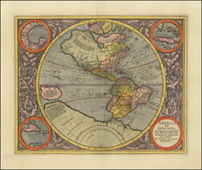
Striking Example of Michael Mercator's Map of the Western Hemisphere, the Only Map he Ever Engraved
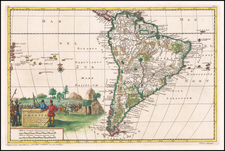
This is a fine example of Mercator's map of the Western Hemisphere, based upon Rumold Mercator's world map of 1587. Fascinatingly, this is the only map that Mercator, Gerard's grandson, engraved. Even so, it shows spectacular skill and artistry.
North and South America are shown above a large southern continent. The Pacific stretches to the west, with a large, round New Guinea at the edge of the hemisphere. To the north, three of the four islands Gerard Mercator typically placed around the North Pole are visible.
There are four insets in the corners, along with decorative scrollwork that again showcases Michael's engraving prowess. In the upper left is the Gulf of Mexico, the upper right Cuba, the lower left Haiti (nunc Hispaniola), and the lower right a title. Although Gerard Mercator is mentioned in the title, Michael is identified as the engraver and Duisberg as the place where he executed the work.
The St. Lawrence River crosses half the northern continent. The search for a water course across North America is interrupted only by some mid-continental mountains. Evidence of the Spanish explorations in the Southwest of North America is present and the Colorado and Gila Rivers already reflect a good knowledge of this area, as does the peninsular Baja California, based upon Ulloa's work. In South America, the Amazon and Rio de la Plata basins are detailed.
Several of the more fascinating early modern cartographic theories adorn the map, including a large inland lake in Canada and a vast unknown southern continent. A phantom treasure island is outlined off the western coast of South America, part of the El Dorado myth, and the giants of Patagonia are noted to the south. Anian regnum, a toponym based off of a Chinese province mentioned in Marco Polo's travels, marks northwest North America, while the Strait of Anian marks a clear passage from Atlantic to Pacific.
Although the map was engraved in 1595, it was clearly drawn earlier, as several of the details evidence. For example, there is no mention of the English in Virginia. Magellan and Columbus are referenced, but not Drake or Cavendish. The hemisphere clearly has not been affected by the cartography of Hogenberg, Mazza, and Ortelius in the late 1580s, wherein they reformed the shape of South America and the Pacific. As previously mentioned, the map is based off of Rumold's 1587 world map and it helped to serve as a posthumous tribute to Gerard Mercator.
Mercator's posthumous atlas
The geography of the map can be explained by events in the Mercator family in the late sixteenth century. Gerard Mercator, the patriarch of the cartography dynasty, died in 1594. Since at least the late 1550s, Mercator had wanted to compile an atlas of the modern world. At the time, this had never been done.
Eventually, Mercator planned a five-volume work that covered the creation of the world, a cosmographical description, a geographical description, a history, and a chronology. The chronology was published first, in 1569, the same year as Mercator's celebrated world map. Then he moved to the geographical description. He was able to release his own edition of Ptolemy, in 1578, but he died before finishing the modern atlas. In 1585 he managed a volume on the German lands, with a volume on Italy in 1589. In sixteen years, all he had finished was the bulk of Europe; the Iberian Peninsula was lacking even from that.
The delay was caused by a variety of causes. There was supposedly a lack of copper plate and, when attained, a lack of engravers to help Gerard. He mentions in a 1583 letter that Hogenberg sometimes helped, but was distracted with his own commissions, and his grandson Johannes also lent a hand.
The year after his death, the entire atlas appeared together, thanks to the work of Gerard's son and grandsons. This would be the first work to use the word "atlas" in the title, Atlas sive Cosmographicae meditations de fabrica Mundi et fabricate figura. In addition to several more maps of Europe that Gerard had finished, his son Rumold included his world map of 1587, which was in turn based on his father's of 1569. Rumold also completed a map of Europe, while Africa and Asia were by Gerard Mercator the younger. His younger brother, Michael, engraved the America map seen here. Together, the atlas contained 107 maps, of which 102 Mercator had prepared, if not published, before his death.
Michael Mercator (ca. 1567-1600) was the son of Arnold Mercator, and brother to Gerard Mercator the Younger. His grandfather (1512-1594), of course, is one of the most famous cartographers of all time. Unlike their sire, unfortunately, his sons and grandsons tended to die young, cutting short their careers as geographers and engravers.
Gerard had six children: Arnold, Emerentia, Dorothes, Bartholomeus, Rumold, and Catharina. In 1552, Mercator moved to Duisburg from Leuven, where lived for the rest of his life. Arnold (1537-1587) produced his first map in 1558 and took on the quotidian operations of the family business. The second son, Bartholomeus (1540-1568), taught geography in Duisberg, but he died in 1568, aged 28. Rumold, the third son, also became an engraver and mapmaker. He spent much of his adult life in London, but returned to Duisberg in 1587; it was he who spearheaded the atlas' publication in 1595.
Arnold died the same year Rumold returned, leaving his three sons (Gerard, Johann, and Michael) to help Rumold and their grandfather. As previously mentioned, Gerard the Younger, Arnold's older son, contributed to the atlas, as did Johann. Michael's contribution is perhaps the most celebrated today, although he could not help his brothers bring out a second edition of the atlas in 1602, having died in 1600. Rumold had also died, in 1599.
Michael is only known to have engraved this one map, although he is also known for another cartographic work. This is the Drake silver medal, a double-hemisphere medallion commemorating Francis Drake's circumnavigation (1577-1580). It is the only medal that he ever made. However, both pieces have earned him an enduring reputation.
States of the map
After the 1602 second edition, the remaining grandsons sold the atlas plates to Jodocus Hondius, who continued to print editions in the seventeenth century. The states can be identified by the signatures on the back of the map. As listed by Burden, they are as follows:
Latin text
1595 E (editions of 1595 and 1602, published in Duisburg)
1606 41 I (edition of 1606 only)
1607 39 I (editions of 1607, 1608, 1611, 1612)
1613 39 M (editions of 1613, 1623, 1630)
1616 40 M (editions of 1616, 1619)
French text
1609 39 I (edition of 1609, 1619)
1613 45 K (edition of 1613)
1628 68(?) S (edition of 1628)
1633 69 S (editions of 1633, 1635, 1639)
Mark Monmonier, Rhumb Lines and Map Wars: A Social History of the Mercator Projection (Chicago: University of Chicago Press, 2004).
J. Keuning, “The History of an Atlas: Mercator-Hondius,” Imago Mundi 4 (1947): 37-62.
Michael Mercator (ca. 1567-1600) was the son of Arnold Mercator, and brother to Gerard Mercator the Younger. His grandfather (1512-1594), of course, is one of the most famous cartographers of all time. Unlike their sire, unfortunately, his sons and grandsons tended to die young, cutting short their careers as geographers and engravers.
Gerard had six children: Arnold, Emerentia, Dorothes, Bartholomeus, Rumold, and Catharina. In 1552, Mercator moved to Duisburg from Leuven, where he lived for the rest of his life. Arnold (1537-1587) produced his first map in 1558 and took on the quotidian operations of the family business. The second son, Bartholomeus (1540-1568), taught geography in Duisberg, but he died in 1568, aged 28. Rumold, the third son, also became an engraver and mapmaker. He spent much of his adult life in London, but returned to Duisberg in 1587; it was he who spearheaded the atlas’ publication in 1595.
Arnold died the same year Rumold returned, leaving his three sons (Gerard, Johann, and Michael) to help Rumold and their grandfather. As previously mentioned, Gerard the Younger, Arnold’s older son, contributed to the atlas, as did Johann. Michael’s contribution is perhaps the most celebrated today, although he could not help his brothers bring out a second edition of the atlas in 1602, having died in 1600. Rumold had also died, in 1599.
Michael is only known to have engraved one map, although he is also known for another cartographic work. This is the Drake silver medal, a double-hemisphere medallion commemorating Francis Drake’s circumnavigation (1577-1580). It is the only medal that he ever made. However, both pieces have earned him an enduring reputation.