|
||

|

|
|

|
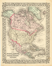
The third known example of this interesting map of North America, printed on linen in Glasgow by R. Gray in 1811, based upon Robert Wilkinson's highly important map of North America from 1804.
As noted by Rumsey:
This is a copy of the 1804 Wilkinson North America map, here printed on linen. . . Wilkinson's map of 1804 has been somewhat simplified to allow for limited detail due to printing on fabric. . . .[w]ith a decorative border of vines and tiny vignettes. [English map dealer] John Faupel suggested this was probably made as a "commemorative" piece in a very small issue.
We found very little about R. Gray, who also seems to have engraved a portrait of Dr. Benjamin Franklin in Glasgow in 1814 (See, Catalogue of the Very Important Collection of Rare Americana and Fine Engravings Formed By The Late Edwin Babcock Holden, #1504, American Art Galleries, April 18, 1910).
Robrt Wilkinson's map of North America is among the rarest and most interesting maps, including one of the earliest depictions of Louisiana Territory and a late depiction of the proposed State of Franklin.
Wilkinson's map (first issued in August 1804) is the first to show the entire Louisiana Territory as part of the United States, which is both shown on the map and in the table showing the possessions of the United States: "Province, Ceded by France 30 Apr. 1803, Louisiana." (the table was removed in Gray's edition of the map). While Abraham Bradley's Map of The United States dated 2 June 1804 is the first map to mention the cession of Louisiana: "The French call the country West of Conecuh River Louisiana & have ceded it to the United States," the Bradley map shows only a small portion of Louisiana Territory just west of the Mississippi River.
Gray faithfull copies much of Wilkinson's map, although occassionally omitting some place names or other information. However, it is clear from a close study of the two maps that Gray was copying Wilkinson. /gallery/detail/19964
Wilkinson's marvelously detailed map follows Arrowsmith's Map Exhibiting all the New Discoveries in the Interior Parts of North America (1802) in the Rocky Mountain and the Oregon River areas, and adds new settlements and place names not on Arrowsmith's map along the northwest coast. Franklinia is shown between Tennessee and North Carolina.
Wheat notes that "New Albion covers the Great Basin and the Pacific Coast north of California, but vies with 'Quivira or Moosemlek [of Lahontan] Indians much civilized having 100 towns and sailing with large vessels. . .
The irony of Wheat's description is that Wheat, unaware of the rare first edition of 1804, was in fact describing the atavistic qualities of this second edition of the map, not realizing that he was in fact looking at a second edition of one of the most interesting and accurate large format maps of North America issued prior to the appearances of the maps of Humboldt, Lewis & Clark, Pike and Stephen Long.
Wilkinson's map is an under-appreciated cartographic llandmark, which was painstakingly compiled by Wilkinson. Other interesting notes include the location of Santa Fe based upon the Astronomical Observations given by Vancouver, the remarkable detail of the River systems shown by Wilkinson in the Transmississippi West (both actual and conjectural) and the numerous Indian Tribes depicted. But for the rarity of the map, it would unquestionably have received much greater attention among collectors and scholars. Until 2008 (Sothebys), no copy of the map had appeared at Auction since the Streeter Sale.
![[Berkeley] This Is The Map of Berkeley Town Its Streets Go Winding Up & Down An Oak-Covered Campus It Wears For A Crown With People & Places of Renown](https://storage.googleapis.com/raremaps/img/small/97201.jpg)


![[ Wyoming Attached To Dakota Territory ] The United States of America](https://storage.googleapis.com/raremaps/img/small/99363.jpg)