|
||

|

|
|

|
Stock# 32726mb
Description
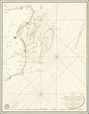
Detailed sea chart showing a portion of the Coast of Kent, from Dover Castle to North Foreland, published by Mount & Page.
The chart shows leading marks to Sandwich, Deal and Ramsgate. It contains two coastal elevations and pictorial representations of landmarks, each of which shows a lighthouse.
A number of coastal details are noted, including towns, castles, Churches and other features.
![[Hungarian Map of Great Britain] Nagy Britannia](https://storage.googleapis.com/raremaps/img/small/85219.jpg)