|
||

|

|
|

|
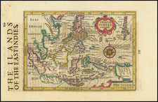
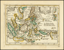
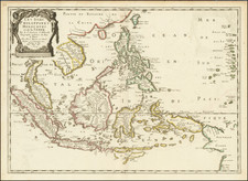
Decorative and detailed map of Southeast Asia, by Nolin and Coronelli, issued immediately prior to the closing of Siam to Europeans in 1688.
Nolin's map is an important map of Southeast Asia, extending from the southern part of the Indochinese Peninsula through to the northern coastline of Java and the eastern part of Borneo. The map is filled with information including extensive soundings along coastlines and historical notations.
The map is the result of France's first embassy to Southeast Asia in 1685, which was led by Chevalier de Chaumont in the company of six Jesuit fathers. The route of the embassy is noted on the map.
The map was a product of the collaboration between Nolin, who was one of the official mapmakers to the King of France, Louis XIV, and Coronelli, who had been invited to Paris by the King to undertake cartographic projects, including the construction of a globe for the King. The result of this collaboration was the most up to date and detailed maps of many parts of the World at a time when France's explorations in America and Asia were of great import.
The Nolin-Coronelli mapping of Southeast Asia would become the standard for many decades after the creation of this map.
Jean-Baptiste Nolin (ca. 1657-1708) was a French engraver who worked at the turn of the eighteenth century. Initially trained by Francois de Poilly, his artistic skills caught the eye of Vincenzo Coronelli when the latter was working in France. Coronelli encouraged the young Nolin to engrave his own maps, which he began to do.
Whereas Nolin was a skilled engraver, he was not an original geographer. He also had a flair for business, adopting monikers like the Geographer to the Duke of Orelans and Engerver to King XIV. He, like many of his contemporaries, borrowed liberally from existing maps. In Nolin’s case, he depended especially on the works of Coronelli and Jean-Nicholas de Tralage, the Sieur de Tillemon. This practice eventually caught Nolin in one of the largest geography scandals of the eighteenth century.
In 1700, Nolin published a large world map which was seen by Claude Delisle, father of the premier mapmaker of his age, Guillaume Delisle. Claude recognized Nolin’s map as being based in part on his son’s work. Guillaume had been working on a manuscript globe for Louis Boucherat, the chancellor of France, with exclusive information about the shape of California and the mouth of the Mississippi River. This information was printed on Nolin’s map. The court ruled in the Delisles’ favor after six years. Nolin had to stop producing that map, but he continued to make others.
Calling Nolin a plagiarist is unfair, as he was engaged in a practice that practically every geographer adopted at the time. Sources were few and copyright laws weak or nonexistent. Nolin’s maps are engraved with considerable skill and are aesthetically engaging.
Nolin’s son, also Jean-Baptiste (1686-1762), continued his father’s business.