


|
||

|

|
|

|
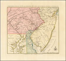
Finely engraved map of the region around Philadelphia, showing the Theater of War in the area of Philadelphia during the American Revolution.
Originally engraved by Bernard Romans in New Haven, Connecticut, in 1778, the map is one of the rarest maps of the American Revolutionary War period. This edition of the map was issued by the Amsterdam firm of Covens & Mortier, based closely on one published by Bernard Romans in New Haven, Connecticut in 1778. It depicts the region within a roughly 75-mile radius of Philadelphia, including much of New Jersey, Pennsylvania, Maryland and Delaware. Major topographical features are shown (with elevations in the archaic "molehill" style), as are rivers and streams, major roads, hundreds of place names, and county and state boundaries. The map is, among other things, one of the earliest to identify Delaware, New Jersey and Pennsylvania as "States" rather than "Colonies" or "Provinces."
Romans produced his map to illustrate the Philadelphia campaign of 1777, which began in August with British General Howe's landing of his troops at the head of the Chesapeake, followed by his defeat of Washington at the Brandywine on September 11, and the capture of Philadelphia at the end of the month. Washington retreated westward and by December the Continental Army was encamped at Valley Forge. The map shows the "tracks" of Howe's advance and Washington's retreat, as well as the "Grand American Winter Camp" at Valley Forge.
Bernard Romans was born in Delft, Netherlands about 1720. He learned mapmaking and surveying in England, before moving to the Colonies in 1757. He served as a Surveyor in Georgia, where he would rise to become Deputy Surveyor General in 1766 and one of the most important Colonial mapmakers. He is perhaps best known for his extensive survey and mapping or the Coastal Waters of East Florida. William Gerard De Braham, the Surveyor General for the Southern Colonies appointed him Deputy Surveyor General for the Southern District in 1773 and wrote A Concise Natural History of East and West Florida, published in 1775, one of the most important works on Florida.
When war broke out in 1775, Romans was in Boston where Paul Revere was engraving Romans' maps of Florida. Romans enlisted in the American cause and was appointed a Captain and served with Benedict Arnold and Nathaniel Greene in their attacks on Fort George and Fort Ticonderoga. Following the Battle of Bunker Hill, Romans publishe d An Exact View of the Late Battle of Charleston, June 17, 1775 and a map of the area around Boston, entitled The Seat of War In America, which he dedicated to John Hancock.
Romans served until June 1778, when he resigned his commission. He rejoined the Southern Campaign in 1780, during which time he was captured by the Royal Navy and imprisoned until the end of the War. He died returning home after the War in 1784 (one account put forth by his family is that he was murdered and thrown overboard).
Romans published several other significiant maps of the American Revolution in New Haven, each of which is essentially unobtainable. In 1778 Romans advertised for sale A Chorographical Map of the Northern Department of North America and A Chorographical Map of the Country Round Philadelphia. He also published Connecticut and parts adjacent, with Abel Buell.
The appearance of three of the Romans maps in editions published in Amsterdam shortly after the publication of the original New Haven versions of the map is a topic worthy of investigation. It is reasonable to speculate that Romans used his Dutch roots to have a set of the maps sent back to Amsterdam for publication
The original Romans map is essentially unobtainable. OCLC locates only the copies at John Carter Brown and the Connecticut Historical Society for the original New Haven imprint. For the Coven & Mortier edition, we are aware of no other examples of this map having been offered for sale at auction or in a dealer catalog in the past 30 years, although one example was acquired privately by a collector through the Arkway firm in the early 1990s (and is currently on display on the Boston Public Library website).
Covens & Mortier was one of the largest and most successful publishing firms in Dutch history and continued in business for over a century. Pierre Mortier the Elder (1661-1711) had obtained a privilege in 1690 to distribute the works of French geographers in the Netherlands. After his widow continued the business for several years, Cornelis (1699-1783) took over in 1719.
In 1721, Mortier forged a partnership with Johannes Covens (1697-1774), who had recently married Cornelis’ sister. They published under the joint name of Covens & Mortier. In 1774, upon the death of his father, Johannes Covens II (1722-1794) took over his father’s share. In 1778, the company changed its name to J. Covens & Zoon, or J. Covens & Son.
Covens II’s son, Cornelis (1764-1825), later inherited the business and brought Petrus Mortier IV back into the fold. Petrus was the great-grandson of Petrus Mortier I. From 1794, the business was called Mortier, Covens & Zoon, or Mortier, Covens, & Son.
The business specialized in publishing French geographers including Deslisle, Jaillot, Janssonius, and Sanson. They also published atlases, for example a 1725 reissue of Frederik de Wit’s Atlas Major and an atlas, with additions, from the works of Guillaume Delisle. There were also Covens & Mortier pocket atlases and town atlases. The company profited from acquiring plates from other geographers as well. For example, the purchased Pieter van der Aa’s plates in 1730. Finally, they also compiled a few maps in house. At their height, they had the largest collection of geographic prints ever assembled in Amsterdam.
![[Right sheet only of: A New Chart of America Florida to New York with the Principal Harbours on a Large Scale, Drawn from the latest Authorities, by Robt Blachford. 1807.]](https://storage.googleapis.com/raremaps/img/small/55819.jpg)
![[ First Map of Pennsylvania Province ] A Map of the Province of Pensilvania Drawn from the Best Authorities By T. Kitchin Gr.](https://storage.googleapis.com/raremaps/img/small/98226.jpg)