


|
||

|

|
|

|
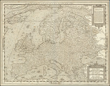
Fine example of Nolin's 4-sheet wall map of Europe, published in London in 1704, including a striking allegorical cartouche.
The map provides a highly detailed look at the European continent, along with a number of sailing ships off the coast of Spain & Portugal (some of which are on fire), with additional ships north of Scotland and off the the coast of Norway. Further north, near Ian Mayen Island, there are images of what would appear to be whaling from long boats and several sea monster. An early exploration route in the Mer de Moscovie and an island discovered by Witsen in 1688 is noted.
A fine example of what may be the first edition of Nolin's map. Our search revealed no other examples earlier than 1740, although earlier editions must certainly exist. A wall map of a similar size dated 1703 and published by Covens & Mortier in Amesterdam references Nolin as one of the sources, although this could also be the result of one of Nolin's other maps.
Jean-Baptiste Nolin (ca. 1657-1708) was a French engraver who worked at the turn of the eighteenth century. Initially trained by Francois de Poilly, his artistic skills caught the eye of Vincenzo Coronelli when the latter was working in France. Coronelli encouraged the young Nolin to engrave his own maps, which he began to do.
Whereas Nolin was a skilled engraver, he was not an original geographer. He also had a flair for business, adopting monikers like the Geographer to the Duke of Orelans and Engerver to King XIV. He, like many of his contemporaries, borrowed liberally from existing maps. In Nolin’s case, he depended especially on the works of Coronelli and Jean-Nicholas de Tralage, the Sieur de Tillemon. This practice eventually caught Nolin in one of the largest geography scandals of the eighteenth century.
In 1700, Nolin published a large world map which was seen by Claude Delisle, father of the premier mapmaker of his age, Guillaume Delisle. Claude recognized Nolin’s map as being based in part on his son’s work. Guillaume had been working on a manuscript globe for Louis Boucherat, the chancellor of France, with exclusive information about the shape of California and the mouth of the Mississippi River. This information was printed on Nolin’s map. The court ruled in the Delisles’ favor after six years. Nolin had to stop producing that map, but he continued to make others.
Calling Nolin a plagiarist is unfair, as he was engaged in a practice that practically every geographer adopted at the time. Sources were few and copyright laws weak or nonexistent. Nolin’s maps are engraved with considerable skill and are aesthetically engaging.
Nolin’s son, also Jean-Baptiste (1686-1762), continued his father’s business.
![[ World & Continents ] Typus Orbis Terrarum / Americae Sive Novi Orbis Nova Descriptio / Asiae Nova Descriptio / Africae Tabula Nova / Europae](https://storage.googleapis.com/raremaps/img/small/99250.jpg)
![[ France ] Galliae Regionis Nova Descriptio](https://storage.googleapis.com/raremaps/img/small/81285.jpg)
![[August 1961: The Berlin Crisis and Foreshadowing Construction of the Berlin Wall]](https://storage.googleapis.com/raremaps/img/small/59512.jpg)