|
||

|

|
|

|
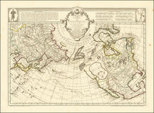
Extremely rare polar map, which accompanied a presentation by Didier Robert de Vaugondy to the French Academy of Sciences, representing possible routes across the north pole.
As noted by Arkway in Catalog 58:
I n August of 1773 Didier Robert de Vaugondy presented a paper to the Academy of Sciences in Paris, accompanied by this striking map of the North Pole. His presentation "discussed three possible routes across the north pole to the Pacific. His map illustrated what he thought was the most feasable of the three: a free and open sea which could be traversed during the summer, taking advantage of the perpetual daylight" -- Pedley. His presentation outlined the problems relating to the mapping of an expedition of this kind, including the kind of compass to take, the method for counting the days in the perpetual daylight, the type of projection to employ, and the measurement of winds and currents. On the map there is a series of dotted spiral lines to represent wind rhumbs, and line gradations showing the certain and uncertain coasts. De Vaugondy also incorporates a good deal of geography which he had previously rejected, including the Lac de Font and Lac Bernarda [here named Ouinipigouchin and Lac Michinipi], as well as the Aleutian Islands in the Bering Strait.
The map is very rare on the market. The only example we have seen is the Arkway copy, catalog 58, #33 (2003).
Gilles Robert de Vaugondy (1688-1766) and Didier Robert de Vaugondy (1723-1786) were influential figures in the realm of 18th-century French cartography. Originating from Paris, their contributions to mapmaking were significant during an era of expansive geographical exploration.
Gilles Robert de Vaugondy entered the world of cartography not through family tradition but through personal interest and the budding opportunities of his time. Born in 1688, he worked during a time when Paris was becoming a central hub for cartographic activities. Gilles often incorporated the latest findings from explorers into his maps, making them sought-after for their contemporary relevance. His connections weren't limited to his immediate circle; he frequently interacted with other key mapmakers, staying updated on the latest techniques and findings.
His son, Didier, was born in 1723 and had the advantage of growing up surrounded by maps and globes. While his father was renowned for maps, Didier made a name for himself in the field of globemaking. His globes were some of the most precise and detailed in France, gaining recognition even among the royalty. In addition to his work in cartography and globemaking, Didier had a keen interest in education, especially after the expulsion of the Jesuits from France. He stepped in to produce geographical educational materials, fulfilling a newfound need.
The maps and globes produced by the Vaugondys remain an enduring testament to the peak of French cartography during the Enlightenment. Their works, characterized by precision and the inclusion of contemporary findings, helped to shape our understanding of the world during a transformative period in European history.
![[ Grodno / Hrodna, Belarus ] Vera Designatio Urbis In Littavia Grodnae](https://storage.googleapis.com/raremaps/img/small/96900.jpg)
![Tabula Geographica Hemisphaerii Borealis ad emenatiora quae adhuc prodieruntexampla jusqu Acad. Reg. Scient. et Eleg. Litt. Boruss. descripta [with:] Tabula Geographica Hemisphaerii Australis...](https://storage.googleapis.com/raremaps/img/small/102686.jpg)
![A New and Accurate Map of Scandinavia or the Northern Crowns of Sweden, Denmark, and Norway [Iceland and Greenland insets]](https://storage.googleapis.com/raremaps/img/small/80246.jpg)