|
||

|

|
|

|
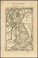
Highly detailed plan of London, with an extensive descriptive key at the bottom and two vignettes in the lower corners, with a compass rose.
Fine early image of early 18th Century London extending North to South from Islington to Lambeth, and East to West from Mile End to Hyde Park. To the left and right of the title is an explanation in French of London and its principal buildings. Below the plan are two views, one of Monument - the great doric column designed by Wren and Hooke to commemorate the Great Fire; and the other, St Mary-le-Bow church; another Wren masterpiece that was completed in 1680 and considered at the time the second most important church in London, after St Paul's.
Also below the plan is a 123 item list of the most important streets, hospitals, churches, public buildings, and gateways. The plan bears grid lines for easy reference.