This item has been sold, but you can enter your email address to be notified if another example becomes available.


|
||

|

|
|

|
Stock# 32383mb
Description
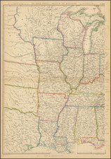
Rare separately issued map of the northern part of Mississippi and Alabama, produced by Andrew and Henry Lindenkohl and lithographed by Krebs at the direction of the US War Department in 1864.
One of the most detailed maps of the region produced during the war, separately produced during the war for field use by Union officers.
During the Civil War, the US Coast Survey Department became the official mapmaking branch of the United States War Department. Under the direction of A.D. Bache, many of the most talented surveyors and mapmakers were employed compiling maps from existing official and commercial sources. Among the most active were the Lindenkohl brothers (Andrew and Henry), whose names appear on a number of these compiled maps.

![Carte De La Louisiane Et Du Cours Du Mississipi . . . Juin 1718 [1st State!]](https://storage.googleapis.com/raremaps/img/small/59797.jpg)
![[First Map of the Mississippi River] Carte de la decouverte faite l'an dans l'Amerique Septentrionale](https://storage.googleapis.com/raremaps/img/small/93571.jpg)