|
||

|

|
|

|
Perhaps the single most important map of the American West issued after Fremont's map of Oregon & Upper California was Lt. Governeur Kemble Warren's monumental map of the Transmississippi West.
Warren's map appeared in a number of editions, each extensively updated, between 1855 and 1868. The first major revison to the map was produced by Edward Freyhold between 1865 and 1868. The present map is one of the editions produced after the surveys of 1867, and as noted by Freyhold, incorporates the original information with "recent and more extensive explorations and surveys." Wheat refers to the Freyhold map as
a tremendously detailed map, detailed beyond any possiblity of description, and reflecting amlost incredible change in the aspect of the United States within a mere eleven-year period. Freyhold's is the first recognizably modern map of the West . . .
. . . We value Freyhold's map for its information, and for mirroring the Transmississippi West at a turning point in history, at thevery close of the pre-railroad era. Students of Western history will return to it again and again . . . for the Freyhold map is beautiful to the eye, a superb example of the mapmaker's art, as well as his science . . .
The history of the map begins during the 1850s, when the U.S. Government sponsored an extensive series of expeditions designed to gather information on the vast new territories that had been acquired in western North America. The discovery of gold in California further stimulated westward traffic and heightened the need for a faster and more convenient way to bring the various parts of the country together.
Under the provisions of the Army Appropriation Act of March 1853, Secretary of War Jefferson Davis was directed to survey possible routes to the Pacific. Five selected routes, roughly following specific parallels, were to be surveyed by parties under the supervision of the Topographical Corps. The most northerly survey, between the 47th and 49th parallels, was under the direction of Isaac Ingalls Stevens, governor of Washington Territory. This route closely approximated that proposed by Asa Whitney in 1849. The ill-fated party under Capt. John W. Gunnison was to explore the route along the 38th and 39th parallels, or the Cochetopa Pass route, advocated by Senator Benton. Because he failed to get John Charles Fremont appointed to head this expedition,Benton promoted two well-publicized, privately financed ventures in the same year, one headed by Edward F. Beale and the other by Fremont. After Gunnison's death at the hands of hostile Indians, Lt. Edward G. Beckwith continued the survey along the 41st parallel. Capt. Amiel W. Whipple, assistant astronomer of the Mexican Boundary Survey, and Lt. Joseph Christmas Ives surveyed the routes of the 35th parallel, westward to southern California. This was essentially the route traversed by Josiah Gregg in 1839 and later surveyed by Col. John J. Abert. When the results of the surveys were analyzed it was apparent that additional data on the roadbeds, grades, and passes were needed for the 32d parallel route to California. Lt. John G. Parke resurveyed along the Gila River between the Pima villages and the Rio Grande. Capt. John Pope mapped the eastern portion of the route from Dona Ana, N. Mex., to the Red River. Topographical surveys to locate passes through the Sierra Nevadas and the Coast Range in California and to determine the route that would connectCalifornia, Oregon, and Washington were made under the direction of Lt. Robert S. Williamson.
In all, there were six major expeditions; five of them covered the area between the Great Plains and west coast, and the sixth explored the coastal states of California and Oregon. All of these expeditions were accompanied by naturalists and artists to document the landscape, flora and fauna along the route. The reports, maps and lithographs were published in the highly important 13 volume Explorations and Surveys to ascertain the most practicable and economical route for a Railroad from the Mississippi river to the Pacific Ocean, which was finally completed in 1859 and is frequently referred to as the Pacific Railroad Survey.
The Pacific Railroad Survey became the basic source material for Lt. Gouverneur Kemble Warren's Map of the Territory of the United States from the Mississippi River to the Pacific Ocean. Because of the accelerating flow of new information, Warren recognized, in his Memoir to Accompany the Map, the difficulty of keeping such a map up to date. He stated that "the work of compilation . . . must necessarily be frequently repeated; and to aid the future compiler, I have prepared the accompanying memoir upon the different maps and books used, and upon the manner in which their discrepancies have been resolved." He gratefully acknowledged the work of Edward Freyhold in "the beautiful execution of the topography upon the map . . . ... The first revision of the map, drawn by Freyhold, was engraved on stone by Julius Bien of New York. The map is in President Millard Fillmore's collection and bears his signature and the date December 19, 1863. This map, like the first edition, lists 45 major surveys and mapping reports from the time of Lewis and Clark to the General Land Office Surveys of the late 1850's.
"Warren's General Map" is a monumentally important and rarely offered map that is considered to be the first accurate overall picture of the region. Wheat considers it so important that he dedicated eight pages to its description and calls it the most important map produced by the Topographical Engineers. Drawn on the polyconic projection, the map culminated a half-century of government explorations beginning with Lewis & Clark. Only 24 years old when assigned the task, Warren used information from the U.S. Land Office, the Coast Survey, Topographical Engineers, the Adjutant General, the Quartermaster General, the Indian Bureau, and Smithsonian Institution to obtain the latest information in developing this map. The majority of the map was completed by 1854, but it was not fully complete when the first railroad survey report was published in 1855 and continued to be issued in revised editions until 1868.
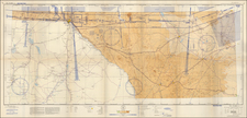
Following the 1867 editions, Freyhold added an inset of Alaska and moved the title of the map into the center of the map. There were apparently multiple editions of the map issued in each year. For example, our example of 1867 edition (colored by Military Departments only) seems to pre-date Rumsey's #2954, which seems to have additional regional titles (The Pacific and The Missouri) and colored state borders. Our example also includes the principal mail routes, railroads finished and railroads unfinished, noted with varying red lines (see Note at bottom center), unlike the Rumsey copy. The Rumsey note seems to bear the same variant "Note" as the Huntington Library copy.
We have located no other examples with the same note and post-road locations.