|
||

|

|
|

|
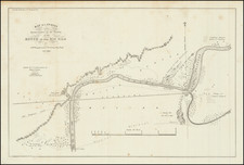
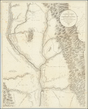
Extremely rare 1859 variant edition of the much sought after large format survey of San Diego Bay, form the US Coast Survey.
The map notes that it is "Redd. drng. by A. Balbach & A. Lindenkohl; engd. by J. Enthoffer, G.B. Metzeroth & J.C. Kondrup." "Electrotype copy no. 4 by G. Mathiot, U.S.C.S." There is also an Electrotype copy no 3.
Extends from False (Mission) Bay and the Pacific Beach area, south to Imperial Beach and the Mexican border. Hundreds of soundings. Shows several of the Ranchos, New San Diego, Old Town, Ballast Pt., La Playa, Valley of Tecolote, a Light House, Valley of Carbonera, and the old and new river beds of the San Diego River, among other things. This is one of three maps of San Diego Bay by the US Coast Survey, the other two (1851 and 1853) are much smaller format.
The most obvious change from this 1857 edition is the use of contour shading to denote teh varying coastal depths, a method not employed on the earlier edition of the map. We also noted an extra place name below La Playa. There are also some minor changes in the notes.
OCLC locates only 1 example of this edition of the map (Bancroft).
The United States Office of the Coast Survey began in 1807, when Thomas Jefferson founded the Survey of the Coast. However, the fledgling office was plagued by the War of 1812 and disagreements over whether it should be civilian or military controlled. The entity was re-founded in 1832 with Ferdinand Rudolph Hassler as its superintendent. Although a civilian agency, many military officers served the office; army officers tended to perform the topographic surveys, while naval officers conducted the hydrographic work.
The Survey’s history was greatly affected by larger events in American history. During the Civil War, while the agency was led by Alexander Dallas Bache (Benjamin Franklin’s grandson), the Survey provided the Union army with charts. Survey personnel accompanied blockading squadrons in the field, making new charts in the process.
After the Civil War, as the country was settled, the Coast Survey sent parties to make new maps, employing scientists and naturalists like John Muir and Louis Agassiz in the process. By 1926, the Survey expanded their purview further to include aeronautical charts. During the Great Depression, the Coast Survey employed over 10,000 people and in the Second World War the office oversaw the production of 100 million maps for the Allies. Since 1970, the Coastal and Geodetic Survey has formed part of the National Oceanic and Atmospheric Administration (NOAA) and it is still producing navigational products and services today.