|
||

|

|
|

|
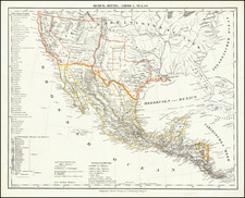
Rare and highly important map of of the "Old Territory and Military Department of Utah, prepared "chiefly for military purposes," by the United States Bureau of Topographical Engineers in 1859 and revised to 1867.
The New Mexico Military Department map is one of the rarest government published maps of the Southwestern United States and is generally regarded as the best map of New Mexico Territory published prior to (and revised after) the Civil War.
The list of Authorities identifies 19 maps created by various explorers of the region, most of which were published between 1843 and 1858, including several maps which may have been known in manuscript form only. Perhaps the most noteworthy updated is the inclusion of new information from the Official Territorial Map of Arizona published by Gird in 1865.
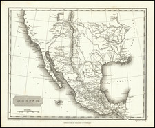
This map captures New Mexico in the midst of its most tumultuous years since the Pueblo Revolt. The resolution of the Mexican-American War required extensive surveys, boundary adjustments, negotiations with Texas, more boundary adjustments, a purchase of additional land from Mexico, more boundary adjustments, and the creation of the Arizona Territory, requiring additional boundary adjustments.
General Kearny had promised New Mexicans an end to the raiding from the many nomadic tribes surrounding the Spanish settlements. U.S. Army constructed numerous forts to protect both the settlements and the routes of travel into and inside New Mexico. These forts became a target for the Confederate Army, when forces led by Henry Hopkins Sibley invaded, with the hopes of reaching the richer gold fields of Colorado, or even California, giving the Confederates another sea port. Sibley's hopes were dashed by the end of 1862, but the rest of the Confederacy kept going until 1865.
After that, the Army's attention turned back to securing the western frontiers. Raids in New Mexico had increased while the Anglos fought each other, and the U.S. Army was willing to back an ambitious, but ill-conceived plan to remove nomadic natives from their homelands and turn them into peaceful farmers. The Indian Wars in New Mexico lasted longer than anywhere else, and ended with the surrender of Geronimo's band of Chiricahua Apache in 1881.
The map is of the utmost rarity. Wheat (who illustrates the map as #967) describes the 1859 edition of the map as "about the best map that could have been made of the New Mexico Territory of its period." He does not list or reference the 1867 edition, which would seem to be a bit rarer. There is also an 1871 edition of the map, which for which OCLC lists 1 copy. OCLC lists copies of the 1867 edition at the Library of Congress, Yale, Penn, British Library and Bibliotheque Nationale de France. The Newberry and 3 Arizona instutions list what appears to be a reduced size photostatic copy of the map.
![Air Log Western Air Express [Los Angeles-San Diego, Las Vegas-Los Angeles, Milford-Vegas, Salt Lake City-Milford]](https://storage.googleapis.com/raremaps/img/small/85953.jpg)
![[ Western United States -- Massive Idaho Territory ]](https://storage.googleapis.com/raremaps/img/small/99057.jpg)