This item has been sold, but you can enter your email address to be notified if another example becomes available.


|
||

|

|
|

|
Stock# 32253
Description
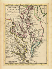
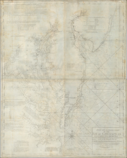
Rare Civil War map of the Southeast, extending from Maryland to the northern part of North Carolina.
The map covers the Chesapeake and Maryland regions, showing roads, railroads, towns, villages and soundings.
The map is known in 3 states, of which this is state 2, which includes the symbol for batteries which is not present in the first edition, and including the name of the Bien as lithographer, which is not present in the third edition.
All editions of the map are extremely rare. This is the first example we have seen on the market.
Condition Description
Flattened and backed with archival paper, with a number of small chips missing

![[St. Helena] The True Description of the Island of Ascention lyeing under 8 degrees on ye South syde of ye Equinoctiall lyne.](https://storage.googleapis.com/raremaps/img/small/78964.jpg)