![[Republic of Texas] Map of Texas From the most recent authorities . . . 1845 By Henry Schenk Tanner](https://storage.googleapis.com/raremaps/img/small/43437.jpg)


|
||

|

|
|

|
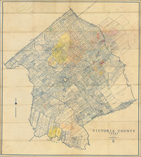
Nice example of the early map Texas, issued in Samuel Augustus Mitchell's Universal Atlas.
This is the first edition of the map to include the Mitchell decorative "rope" border. The map is noteworthy as the first map in the Tanner-Mitchell sequence to delete the so-called "Judicial Counties" (see below).
While a number of counties are shown in the east, the Western part of the Republic is still dominated by Bexar, Milam, and Robertson County, with a massive San Patricio County in the south. Fort Alamo is shown, along with a few dozen other place names. About 15 early roads are shown.
The map includes a large inset map of Texas north of the Red River.
Dating the Map
The map includes Fannin County, established March 13, 1846. Curiously, the Fannin Land District is not shown. Created on March 14, 1846. Fannin Land District was eliminated and became part of Cooke Land District and Denton Land District when those districts were reorganized and expanded on February 13, 1854.
The map does NOT show Leon County or Grayson County, which were formed 3 days after Fannin County, on March 16, 1846, nor do they show the group of counties formed on March 23, 1846 (Comal County, De Witt County, Anderson County, Burleson County),
Judicial Counties
The present map is quite curious, as it includes a number of counties that ceased to exist in 1842.
The map is dated 1845 and retains the border characteristic of Tanner's last atlases, but includes a number "Judicial Counties." Judicial counties had many of the same legal characteristics of "Constitutional Counties" (ie. counties formed under the Texas Constitution), but lacked representation at Burleson, Burnet, DeWitt, Guadalupe, Hamilton, La Baca, Madison, Menard, Neches, Panola, Paschal, Smith, Spring Creek, Trinity, Ward, and Waco. These counties were established for judicial and other purposes on January 1841, and abolished by a Texas Supreme Court decision, Stockton v. Montgomery (1842), which declared all judicial counties unconstitutional.
Samuel Augustus Mitchell Jr. inherited the Mitchell Company from his father in 1860. For over thirty years, the company had specialized in the production of school atlases and wall maps of America. They were one of the pioneers on engraving on steel plates. In 1860, Samuel Jr. released the New General Atlas, which had been compiled in house and replaced a previous atlas by Tanner. The elder Mitchell died in 1868 and Samuel Jr. continued the business until the 1890s. At its height, the Mitchell Company employed 250 people and sold 400,000 publications annually.
![Nouvelle Carte Du Mexique, Du Texas Et D'Une Partie Des Etats Limitrophes . . . 1840 [Proposed Railroads In Texas -- First Appearance of Arizona on a Printed Map]](https://storage.googleapis.com/raremaps/img/small/103480.jpg)
![Carta geografica della Florida nell'America settentrionale [Geographical map of Florida in North America]](https://storage.googleapis.com/raremaps/img/small/84142.jpg)