|
||

|

|
|

|
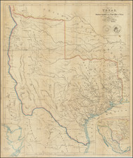
First edition of this remarkable map of the region bounded by Texas, Colorado and Nebraska, centered on Indian Territory, prepared by the the United States Topographical Engineers for the War Department in 1867.
The map provides a remarkable overview of the region at the conclusion of the Civil War, including perhaps the most detailed treatment of the railroads (existing and proposed) and road system in the region, along the regions topographical and hydrographical regions. In INdiana Territory, the existing boundaries of the variou Indian Nations are delineated. The map also identifies the 20 major military stations in the region, including in most instances the coordinates and commanding officers, along with a list of nearly 30 maps and surveys which were incorporated into the map.
In describing his copy of the first edition of the map (which had previously been owned and annotated by William E. Merrill, Major in the Topographical Engineers Department, Rumsey noted:
. . .Not in Streeter, Phillips, Wheat. Map shows routes of important reconnaissances, Indian trails, roads, railroads in operation, projected railroads, army routes, Indian lands and reservations. One of the earliest detailed Army surveys of the area. The map was printed in two sheets, a north sheet and a south sheet. The north sheet appears in the Atlas to Accompany the Official Records of the Union and Confederate Armies as Plate CXIX, with the same title as this map, but with the title placed in the upper right corner of the north sheet. We also have the North sheet without title, dated c1875, with much additional information on new routes, railroads, etc. . .
The map is one of several regional maps of the Western United States prepared at the conclusion of the War, but which are now virtually unobtainable. Given its rarity on the market, it must be surmised that it was issued for use only by senior military officials and was circulated in very limited numbers. As noted by David Rumsey, equally rare second edition of the map appeared in 1875, withwith more routes, battles and other updated information included.
The map is of the utmost rarity and was apparently unknown to Wheat and not listed in Philips. Among US institutions, OCLC locates only the copies at the Newberry Library, University of Wisconsin, Milwaukee and the University of Kanas, with no copies appearing in any Texas, Colorado or Oklahoma Institutions. We were unable to locate any auction records for the map going back over 50 years, with the only catalog appearance for the map being a 1971 Goodspeed's Catalog (Catalog 567, #112).
A fine example of this legendary rarity, the first example we have ever seen offered for sale.

![Les Etats Unis de L'Amerique Septentrionale Partie Occidentale [The United States of North America Western Part]](https://storage.googleapis.com/raremaps/img/small/98752.jpg)

![Charte von Den Vereinigten Staaten von Nord-America nebst Louisiana . . . 1805 [Rare 1st State of Gussefeld's Louisiana Purchase Map]](https://storage.googleapis.com/raremaps/img/small/63496.jpg)