|
||

|

|
|

|
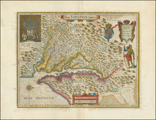
Rare separately issued example of John Speed's map of the Northeast, likely printed prior to the publication of the 1676 edition of Speed's Prospect of the World.
The map may be distinguished as a separately issued example by the lack of text on the verso. As noted by Philip Burden, the 1676 edition of Speed's Atlas was was available by February 10, 1676, according to contemporary advertisements in the Term Catalogues. However, the Hilary Term 1674-75, published in February 1675, the publisher of the atlas announced that prior to publication of the complete atlas, "Maps will be sold without description separately." Burden continues that
The text on the reverse of the map describes the region, although examples ar known without it. Thses plain back versions were undoubtedly offered separately to a market eager for maps of a specific area. The example in the British Library is printed on thicker paper.
Burden does not note any separately issued examples of the Virginia & Maryland map by Speed, and only a single example of the Carolinas map without text (John Carter Brown), suggesting that these separately issued examples are of the utmost rarity. The present example would seem to have been trimmed to the neatlines and laid on a larger sheet of 17th Century English paper at the time of its publication, as there is no evidence of a separate fold, except the one on the larger sheet, suggesting that this example was bound into a composite atlas sometime in thea late 17th Century, shortly after its printing.
Speed's map is one of the earliest maps to illustrate dramatic shift from Dutch to English dominance in the Northeast in the latter part of the 17th Century and one of the earliest to use the term New York for both Manhattan (formerly New Amsterdam) and New York State, as well as one of the earliest appearances of New Iarsey (Jersey).
As noted by Michael Buehler, Speed's map shares the traits of many other regional maps of the period: a haphazard depiction of the St. Lawrence, no sign of Lake Ontario, Lake Champlain offset far to the East of its actual location, Cape Cod at essentially the same latitude as New York City, and the Delaware River curving eastward to connect with the Hudson. Many of these errors can be traced far back to early 17th-century prototype maps by Samuel Champlain, Adrien Block and others.
One of only a small group of English maps of New England, prior to 1700. Based on Jansson's map of 1651, it illustrates the territories acquired by the British with the capture of New Amsterdam in 1664, which radically adjusted the landscape North American politics. While the map's geographical features are largely drawn from Jansson, the map's nomenclature is substantially anglicized, including the first appearance of name Boston (ommitted from the Jansson maps) and the use of the names New York and Cape Cod.
The map is richly embellished with various animals in the interiior of the map, two compass roses, two cartouches and a coat of arms. Engraved by Francis Lamb after Speed's death, the map appeared in the 1676 edition of Speed's Prospect of the Most Famous Parts of the World, bearing the imprint of Bassett & Chiswell and was also issued separately.
John Speed (1551 or '52 - 28 July 1629) was the best known English mapmaker of the Stuart period. Speed came to mapmaking late in life, producing his first maps in the 1590s and entering the trade in earnest when he was almost 60 years old.
John Speed's fame, which continues to this day, lies with two atlases, The Theatre of the Empire of Great Britaine (first published 1612), and the Prospect of the Most Famous Parts of the World (1627). While The Theatre ... started as solely a county atlas, it grew into an impressive world atlas with the inclusion of the Prospect in 1627. The plates for the atlas passed through many hands in the 17th century, and the book finally reached its apotheosis in 1676 when it was published by Thomas Bassett and Richard Chiswell, with a number of important maps added for the first time.
![Dominia Anglorum in America Septentrionali Specialibus Mappis Londini primum a Mollio… [4 maps--New England; Chesapeake, Georgia, Carolinas & Florida; and Nova Scotia…]](https://storage.googleapis.com/raremaps/img/small/60331.jpg)
![(Three Days at Gettysburg) Map of the Battlefield of Gettysburg July 1st, 2nd, 3rd 1863. . . [Three Maps]](https://storage.googleapis.com/raremaps/img/small/101769.jpg)
![Carte Du Canada ou de la Nouvelle France et des Decouvertes qui y ont ete faites . . . [Map of Canada or New France and the Discoveries Made Therein . . .]](https://storage.googleapis.com/raremaps/img/small/94450.jpg)